Usmajac geodata
Usmajac (Jalisco) is a populated place; located in Mexico in America/Mexico_City (GMT-6) time zone. With population of 7,269 people, there are 1275 cities with bigger population in this country. Compared to other cities in Mexico, 54.6% of cities are located further ↓South; 88.5% of cities are located further →East and 51.4% of cities have higher elevation than Usmajac. Note1


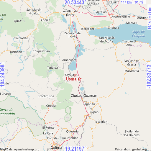
Usmajac GPS coordinates[2]
19° 52' 28.488" North, 103° 32' 27.06" West
| Map corner | latitude | longitude |
|---|---|---|
| Upper-left | 20.53443°, | -104.24398° |
| Center: | 19.87458°, | -103.54085° |
| Lower-right: | 19.21197°, | -102.83773° |
| Map W x H: | 147×147 km | = 91.3×91.3mi |
| max Lat: | 32.7° ⇑45.4% North |
| Usmajac: | 19.87458° |
| min Lat: | ⇓54.6% South 14.53588° |
| min Long | Usmajac | max Long |
| -117.105° | -103.54085° | -86.73105° |
| W 11.5%⇐ | ⇒88.5% E |
Elevation
Elevation of Usmajac is 1364 m = 4475 ft, and this is 110.3 m = 362 ft above average elevation for this country.
| Max E: |
3497 m = 11473 ft | 51.4% |
| Usmajac | 1364 m 4475 ft | |
| Avg. | 1253.7 m = 4113 ft | |
Min E: |
-1 m = -3 ft | 48.6% |
See also: Mexico elevation on elevation.city.
Geographical zone
Usmajac is located in North Torrid zone (between Equator and Tropic of Cancer). Distance of this Northern Tropic circle is 396.1 km =246.1 mi to North.| Distance of | km | miles | from Usmajac |
|---|---|---|---|
| North Pole | 7797.2 | 4845 | to North |
| Arctic Circle | 5191.3 | 3225.7 | to North |
| Tropic Cancer | 396.1 | 246.1 | to North |
| Equator | 2209.8 | 1373.1 | to South |


Nearby cities:
15 places around Usmajac: (largest is in red/bold)
• Amacueca
16.3 km =10.1 mi,  337°
337°
• Apango
20.7 km =12.9 mi,  239°
239°
• Atacco
21.9 km =13.6 mi,  285°
285°
• Atoyac
15.2 km =9.4 mi,  9°
9°
• Ciudad Guzmán
20.6 km =12.8 mi,  156°
156°
• Cuyacapan
10.5 km =6.5 mi, 9°
• El Rodeo
11.6 km =7.2 mi,  108°
108°
• Gómez Farías
11.2 km =7 mi,  143°
143°
• San Andrés Ixtlán
9.7 km =6 mi,  129°
129°
• San Antonio
20.3 km =12.6 mi,  300°
300°
• San Sebastián del Sur
11.4 km =7.1 mi, 141°
• Sayula
6.3 km =3.9 mi,  277°
277°
• Techaluta de Montenegro
22.1 km =13.7 mi,  357°
357°
• Tepec
16.5 km =10.3 mi,  320°
320°
• Unión de Guadalupe
10.2 km =6.3 mi,  67°
67°
Sources, notices
• [Note1] Compared only with cities in Mexico existing in our database
• [Src1] Map data: © OpenStreetMap contributors (CC-BY-SA)
• [Src2] Other city data from geonames.org with taken over terms of usage.
• [Src3] Geographical zone / Annual Mean Temperature by Robert A. Rohde @ Wikipedia
