El Carrizal geodata
El Carrizal (San Luis Potosí) is a populated place; located in Mexico in America/Mexico_City (GMT-6) time zone. With population of 1,081 people, there are 8061 cities with bigger population in this country. Compared to other cities in Mexico, 85.9% of cities are located further ↓South; 74.7% of cities are located further →East and 66.4% of cities have lower elevation than El Carrizal. Note1


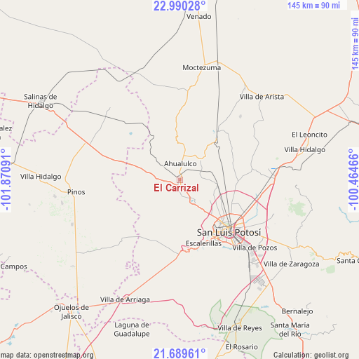
El Carrizal GPS coordinates[2]
22° 20' 29.256" North, 101° 10' 4.008" West
| Map corner | latitude | longitude |
|---|---|---|
| Upper-left | 22.99028°, | -101.87091° |
| Center: | 22.34146°, | -101.16778° |
| Lower-right: | 21.68961°, | -100.46466° |
| Map W x H: | 144.6×144.6 km | = 89.9×89.9mi |
| max Lat: | 32.7° ⇑14.1% North |
| El Carrizal: | 22.34146° |
| min Lat: | ⇓85.9% South 14.53588° |
| min Long | El Carrizal | max Long |
| -117.105° | -101.16778° | -86.73105° |
| W 25.3%⇐ | ⇒74.7% E |
Elevation
Elevation of El Carrizal is 1858 m = 6096 ft, and this is 604.3 m = 1983 ft above average elevation for this country.
| Max E: |
3497 m = 11473 ft | 33.6% |
| El Carrizal | 1858 m 6096 ft | |
| Avg. | 1253.7 m = 4113 ft | |
Min E: |
-1 m = -3 ft | 66.4% |
See also: Mexico elevation on elevation.city.
Geographical zone
El Carrizal is located in North Torrid zone (between Equator and Tropic of Cancer). Distance of this Northern Tropic circle is 121.8 km =75.7 mi to North.| Distance of | km | miles | from El Carrizal |
|---|---|---|---|
| North Pole | 7522.9 | 4674.5 | to North |
| Arctic Circle | 4917 | 3055.3 | to North |
| Tropic Cancer | 121.8 | 75.7 | to North |
| Equator | 2484.1 | 1543.5 | to South |


Nearby cities:
15 places around El Carrizal: (largest is in red/bold)
• Ahualulco del Sonido Trece
6.5 km =4 mi,  1°
1°
• Barrancas
7.5 km =4.7 mi,  258°
258°
• Cerrito de Rojas
11.5 km =7.1 mi,  348°
348°
• Colonia Emiliano Zapata (El Chamizal)
9.2 km =5.7 mi,  42°
42°
• Derramaderos
6.2 km =3.9 mi,  149°
149°
• Las Moras
12.3 km =7.6 mi,  133°
133°
• Mexquitic de Carmona
10.1 km =6.3 mi, 145°
• Milpillas
10.7 km =6.6 mi,  158°
158°
• Palmar Primero
7.9 km =4.9 mi,  65°
65°
• Paso Bonito
9.8 km =6.1 mi, 259°
• Puerto de Providencia
10.8 km =6.7 mi,  75°
75°
• Ranchería de Guadalupe
4.3 km =2.7 mi,  234°
234°
• Rincón de San José
6.5 km =4 mi,  176°
176°
• Rincón del Porvenir
2.2 km =1.4 mi,  203°
203°
• San Juan (San Juan de Coyotillos)
4.4 km =2.7 mi,  356°
356°
Sources, notices
• [Note1] Compared only with cities in Mexico existing in our database
• [Src1] Map data: © OpenStreetMap contributors (CC-BY-SA)
• [Src2] Other city data from geonames.org with taken over terms of usage.
• [Src3] Geographical zone / Annual Mean Temperature by Robert A. Rohde @ Wikipedia
