Barrancas geodata
Barrancas (San Luis Potosí) is a populated place; located in Mexico in America/Mexico_City (GMT-6) time zone. With population of 537 people, there are 15796 cities with bigger population in this country. Compared to other cities in Mexico, 85.9% of cities are located further ↓South; 75.2% of cities are located further →East and 68.9% of cities have lower elevation than Barrancas. Note1


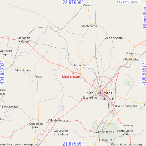
Barrancas GPS coordinates[2]
22° 19' 39" North, 101° 14' 20.004" West
| Map corner | latitude | longitude |
|---|---|---|
| Upper-left | 22.97638°, | -101.94202° |
| Center: | 22.3275°, | -101.23889° |
| Lower-right: | 21.67559°, | -100.53577° |
| Map W x H: | 144.6×144.6 km | = 89.9×89.9mi |
| max Lat: | 32.7° ⇑14.1% North |
| Barrancas: | 22.3275° |
| min Lat: | ⇓85.9% South 14.53588° |
| min Long | Barrancas | max Long |
| -117.105° | -101.23889° | -86.73105° |
| W 24.8%⇐ | ⇒75.2% E |
Elevation
Elevation of Barrancas is 1906 m = 6253 ft, and this is 652.3 m = 2140 ft above average elevation for this country.
| Max E: |
3497 m = 11473 ft | 31.1% |
| Barrancas | 1906 m 6253 ft | |
| Avg. | 1253.7 m = 4113 ft | |
Min E: |
-1 m = -3 ft | 68.9% |
See also: Mexico elevation on elevation.city.
Geographical zone
Barrancas is located in North Torrid zone (between Equator and Tropic of Cancer). Distance of this Northern Tropic circle is 123.3 km =76.6 mi to North.| Distance of | km | miles | from Barrancas |
|---|---|---|---|
| North Pole | 7524.5 | 4675.5 | to North |
| Arctic Circle | 4918.6 | 3056.3 | to North |
| Tropic Cancer | 123.3 | 76.6 | to North |
| Equator | 2482.6 | 1542.6 | to South |


Nearby cities:
15 places around Barrancas: (largest is in red/bold)
• Ahualulco del Sonido Trece
11 km =6.8 mi,  42°
42°
• Cerrito de Rojas
13.8 km =8.6 mi,  21°
21°
• Derramaderos
11.2 km =7 mi,  110°
110°
• El Carrizal
7.5 km =4.7 mi,  78°
78°
• Encarnación
10.8 km =6.7 mi,  314°
314°
• La Tapona
11.4 km =7.1 mi,  172°
172°
• Mexquitic de Carmona
14.6 km =9.1 mi,  117°
117°
• Milpillas
14 km =8.7 mi,  126°
126°
• Palmar Primero
15.2 km =9.4 mi,  71°
71°
• Paso Bonito
2.4 km =1.5 mi,  263°
263°
• Ranchería de Guadalupe
4 km =2.5 mi,  103°
103°
• Rincón de San José
9.2 km =5.7 mi, 122°
• Rincón del Porvenir
6.4 km =4 mi,  94°
94°
• San Juan (San Juan de Coyotillos)
9.2 km =5.7 mi,  49°
49°
• Santa Teresa
9.3 km =5.8 mi, 314°
Sources, notices
• [Note1] Compared only with cities in Mexico existing in our database
• [Src1] Map data: © OpenStreetMap contributors (CC-BY-SA)
• [Src2] Other city data from geonames.org with taken over terms of usage.
• [Src3] Geographical zone / Annual Mean Temperature by Robert A. Rohde @ Wikipedia
