La Vega geodata
La Vega (Jalisco) is a populated place; located in Mexico in America/Mexico_City (GMT-6) time zone. With population of 1,663 people, there are 5226 cities with bigger population in this country. Compared to other cities in Mexico, 69.6% of cities are located further ↓South; 89.6% of cities are located further →East and 53.6% of cities have higher elevation than La Vega. Note1


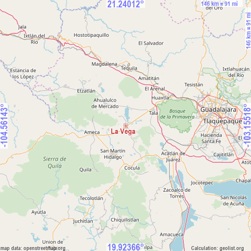
La Vega GPS coordinates[2]
20° 34' 59.916" North, 103° 51' 29.88" West
| Map corner | latitude | longitude |
|---|---|---|
| Upper-left | 21.24012°, | -104.56143° |
| Center: | 20.58331°, | -103.8583° |
| Lower-right: | 19.92366°, | -103.15518° |
| Map W x H: | 146.4×146.4 km | = 91×91mi |
| max Lat: | 32.7° ⇑30.4% North |
| La Vega: | 20.58331° |
| min Lat: | ⇓69.6% South 14.53588° |
| min Long | La Vega | max Long |
| -117.105° | -103.8583° | -86.73105° |
| W 10.4%⇐ | ⇒89.6% E |
Elevation
Elevation of La Vega is 1263 m = 4144 ft, and this is 9.3 m = 31 ft above average elevation for this country.
| Max E: |
3497 m = 11473 ft | 53.6% |
| La Vega | 1263 m 4144 ft | |
| Avg. | 1253.7 m = 4113 ft | |
Min E: |
-1 m = -3 ft | 46.4% |
See also: Mexico elevation on elevation.city.
Geographical zone
La Vega is located in North Torrid zone (between Equator and Tropic of Cancer). Distance of this Northern Tropic circle is 317.3 km =197.2 mi to North.| Distance of | km | miles | from La Vega |
|---|---|---|---|
| North Pole | 7718.4 | 4796 | to North |
| Arctic Circle | 5112.5 | 3176.8 | to North |
| Tropic Cancer | 317.3 | 197.2 | to North |
| Equator | 2288.6 | 1422.1 | to South |


Nearby cities:
15 places around La Vega: (largest is in red/bold)
• Buenavista
1.8 km =1.1 mi,  158°
158°
• Camichinas
11.1 km =6.9 mi,  147°
147°
• Castro Urdiales
4.2 km =2.6 mi,  68°
68°
• Cuisillos
9.2 km =5.7 mi, 71°
• El Amarillo
6.5 km =4 mi,  324°
324°
• El Carmen
9.6 km =6 mi, 324°
• El Ranchito (San Isidro)
8 km =5 mi,  75°
75°
• El Salitre
8.1 km =5 mi,  179°
179°
• La Estanzuela
10.1 km =6.3 mi,  19°
19°
• La Estanzuela
11.6 km =7.2 mi, 180°
• Los Pocitos
9.7 km =6 mi,  238°
238°
• Portes Gil
11.8 km =7.3 mi,  314°
314°
• Punta de la Vega
4.2 km =2.6 mi,  281°
281°
• Teuchitlán
11.3 km =7 mi,  4°
4°
• Trapiche de Abra
6.3 km =3.9 mi,  140°
140°
Sources, notices
• [Note1] Compared only with cities in Mexico existing in our database
• [Src1] Map data: © OpenStreetMap contributors (CC-BY-SA)
• [Src2] Other city data from geonames.org with taken over terms of usage.
• [Src3] Geographical zone / Annual Mean Temperature by Robert A. Rohde @ Wikipedia
