Aconchi geodata
Aconchi (Sonora) is a seat of a second-order administrative division; located in Mexico in America/Hermosillo (GMT-7) time zone. With population of 1,741 people, there are 4986 cities with bigger population in this country. Compared to other cities in Mexico, 98.4% of cities are located further ↓South; 98.3% of cities are located further →East and 66.4% of cities have higher elevation than Aconchi. Note1


Aconchi GPS coordinates[2]
29° 49' 34.608" North, 110° 13' 29.712" West
| Map corner | latitude | longitude |
|---|---|---|
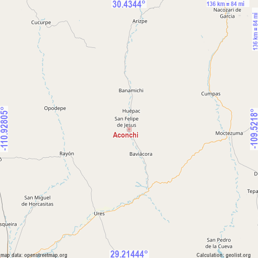
| Upper-left | 30.4344°, | -110.92805° |
| Center: | 29.82628°, | -110.22492° |
| Lower-right: | 29.21444°, | -109.5218° |
| Map W x H: | 135.6×135.6 km | = 84.3×84.3mi |
| max Lat: | 32.7° ⇑1.6% North |
| Aconchi: | 29.82628° |
| min Lat: | ⇓98.4% South 14.53588° |
| min Long | Aconchi | max Long |
| -117.105° | -110.22492° | -86.73105° |
| W 1.7%⇐ | ⇒98.3% E |
Elevation
Elevation of Aconchi is 617 m = 2024 ft, and this is 636.7 m = 2089 ft below average elevation for this country.
| Max E: |
3497 m = 11473 ft | 66.4% |
| Avg. | 1253.7 m = 4113 ft | |
| Aconchi | 617 m = 2024 ft | |
Min E: |
-1 m = -3 ft | 33.6% |
See also: Mexico elevation on elevation.city.
Geographical zone
Aconchi is located in North temperate zone (between Tropic of Cancer and the Arctic Circle). Distance of this Northern Tropic circle is 710.5 km =441.5 mi to South.| Distance of | km | miles | from Aconchi |
|---|---|---|---|
| North Pole | 6690.7 | 4157.4 | to North |
| Arctic Circle | 4084.8 | 2538.2 | to North |
| Tropic Cancer | 710.5 | 441.5 | to South |
| Equator | 3316.4 | 2060.7 | to South |


Nearby cities:
15 places around Aconchi: (largest is in red/bold)
• Arizpe
57.1 km =35.5 mi,  5°
5°
• Banámichi
20.2 km =12.6 mi,  2°
2°
• Baviácora
13.9 km =8.6 mi,  154°
154°
• Cumpas
46.8 km =29.1 mi,  66°
66°
• Guadalupe
53.7 km =33.4 mi,  203°
203°
• Huépac
9.5 km =5.9 mi, 6°
• Jécori
48.7 km =30.3 mi,  75°
75°
• La Estancia
3.9 km =2.4 mi,  157°
157°
• Los Hoyos
54 km =33.6 mi,  52°
52°
• Moctezuma
52.7 km =32.7 mi,  92°
92°
• Ojo de Agua
47.9 km =29.8 mi,  61°
61°
• Opodepe
40.5 km =25.2 mi,  285°
285°
• Rayón
35.4 km =22 mi,  248°
248°
• San Felipe de Jesús
4.1 km =2.5 mi,  341°
341°
• Ures
47.1 km =29.3 mi, 199°
Sources, notices
• [Note1] Compared only with cities in Mexico existing in our database
• [Src1] Map data: © OpenStreetMap contributors (CC-BY-SA)
• [Src2] Other city data from geonames.org with taken over terms of usage.
• [Src3] Geographical zone / Annual Mean Temperature by Robert A. Rohde @ Wikipedia
