Huépac geodata
Huépac (Sonora) is a seat of a second-order administrative division; located in Mexico in America/Hermosillo (GMT-7) time zone. With population of 725 people, there are 12042 cities with bigger population in this country. Compared to other cities in Mexico, 98.4% of cities are located further ↓South; 98.3% of cities are located further →East and 65.8% of cities have higher elevation than Huépac. Note1


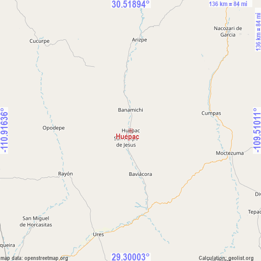
Huépac GPS coordinates[2]
29° 54' 40.86" North, 110° 12' 47.628" West
| Map corner | latitude | longitude |
|---|---|---|
| Upper-left | 30.51894°, | -110.91636° |
| Center: | 29.91135°, | -110.21323° |
| Lower-right: | 29.30003°, | -109.51011° |
| Map W x H: | 135.5×135.5 km | = 84.2×84.2mi |
| max Lat: | 32.7° ⇑1.6% North |
| Huépac: | 29.91135° |
| min Lat: | ⇓98.4% South 14.53588° |
| min Long | Huépac | max Long |
| -117.105° | -110.21323° | -86.73105° |
| W 1.7%⇐ | ⇒98.3% E |
Elevation
Elevation of Huépac is 645 m = 2116 ft, and this is 608.7 m = 1997 ft below average elevation for this country.
| Max E: |
3497 m = 11473 ft | 65.8% |
| Avg. | 1253.7 m = 4113 ft | |
| Huépac | 645 m = 2116 ft | |
Min E: |
-1 m = -3 ft | 34.2% |
See also: Mexico elevation on elevation.city.
Geographical zone
Huépac is located in North temperate zone (between Tropic of Cancer and the Arctic Circle). Distance of this Northern Tropic circle is 719.9 km =447.3 mi to South.| Distance of | km | miles | from Huépac |
|---|---|---|---|
| North Pole | 6681.2 | 4151.5 | to North |
| Arctic Circle | 4075.3 | 2532.3 | to North |
| Tropic Cancer | 719.9 | 447.3 | to South |
| Equator | 3325.8 | 2066.6 | to South |


Nearby cities:
15 places around Huépac: (largest is in red/bold)
• Aconchi
9.5 km =5.9 mi,  186°
186°
• Arizpe
47.5 km =29.5 mi,  5°
5°
• Banámichi
10.7 km =6.6 mi,  358°
358°
• Baviácora
22.5 km =14 mi,  167°
167°
• Cumpas
42.7 km =26.5 mi,  77°
77°
• Guadalupe
62.9 km =39.1 mi,  201°
201°
• Jécori
46.1 km =28.6 mi,  86°
86°
• La Estancia
13.1 km =8.1 mi,  178°
178°
• Los Hoyos
47.8 km =29.7 mi,  60°
60°
• Moctezuma
52.8 km =32.8 mi,  102°
102°
• Ojo de Agua
43 km =26.7 mi,  71°
71°
• Opodepe
40.1 km =24.9 mi,  272°
272°
• Rayón
40.7 km =25.3 mi,  237°
237°
• San Felipe de Jesús
6 km =3.7 mi, 203°
• Ures
56.4 km =35 mi, 197°
Sources, notices
• [Note1] Compared only with cities in Mexico existing in our database
• [Src1] Map data: © OpenStreetMap contributors (CC-BY-SA)
• [Src2] Other city data from geonames.org with taken over terms of usage.
• [Src3] Geographical zone / Annual Mean Temperature by Robert A. Rohde @ Wikipedia
