Cuisillos geodata
Cuisillos (Jalisco) is a populated place; located in Mexico in America/Mexico_City (GMT-6) time zone. With population of 3,663 people, there are 2504 cities with bigger population in this country. Compared to other cities in Mexico, 70.2% of cities are located further ↓South; 89.3% of cities are located further →East and 53.3% of cities have higher elevation than Cuisillos. Note1


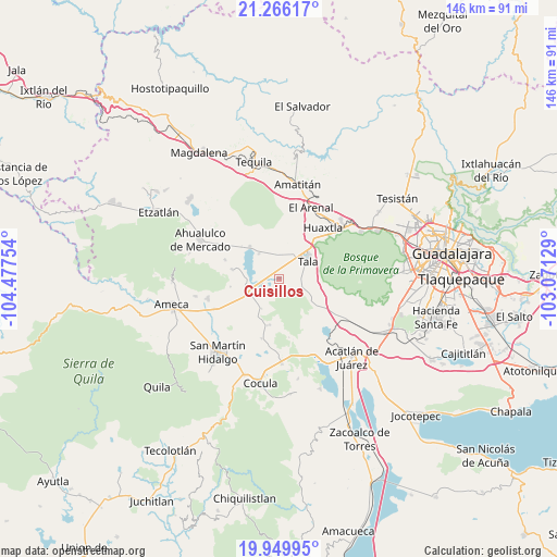
Cuisillos GPS coordinates[2]
20° 36' 34.128" North, 103° 46' 27.876" West
| Map corner | latitude | longitude |
|---|---|---|
| Upper-left | 21.26617°, | -104.47754° |
| Center: | 20.60948°, | -103.77441° |
| Lower-right: | 19.94995°, | -103.07129° |
| Map W x H: | 146.3×146.4 km | = 90.9×91mi |
| max Lat: | 32.7° ⇑29.8% North |
| Cuisillos: | 20.60948° |
| min Lat: | ⇓70.2% South 14.53588° |
| min Long | Cuisillos | max Long |
| -117.105° | -103.77441° | -86.73105° |
| W 10.7%⇐ | ⇒89.3% E |
Elevation
Elevation of Cuisillos is 1275 m = 4183 ft, and this is 21.3 m = 70 ft above average elevation for this country.
| Max E: |
3497 m = 11473 ft | 53.3% |
| Cuisillos | 1275 m 4183 ft | |
| Avg. | 1253.7 m = 4113 ft | |
Min E: |
-1 m = -3 ft | 46.7% |
See also: Mexico elevation on elevation.city.
Geographical zone
Cuisillos is located in North Torrid zone (between Equator and Tropic of Cancer). Distance of this Northern Tropic circle is 314.4 km =195.4 mi to North.| Distance of | km | miles | from Cuisillos |
|---|---|---|---|
| North Pole | 7715.5 | 4794.2 | to North |
| Arctic Circle | 5109.6 | 3175 | to North |
| Tropic Cancer | 314.4 | 195.4 | to North |
| Equator | 2291.6 | 1423.9 | to South |


Nearby cities:
15 places around Cuisillos: (largest is in red/bold)
• Ahuisculco
8.7 km =5.4 mi,  121°
121°
• Buenavista
9.3 km =5.8 mi,  240°
240°
• Camichinas
12.5 km =7.8 mi,  192°
192°
• Castro Urdiales
5 km =3.1 mi,  254°
254°
• El Amarillo
12.7 km =7.9 mi,  280°
280°
• El Ranchito (San Isidro)
1.3 km =0.8 mi,  227°
227°
• El Refugio
7.8 km =4.8 mi,  27°
27°
• La Estanzuela
8.5 km =5.3 mi,  320°
320°
• La Vega
9.2 km =5.7 mi, 251°
• Navajas
13 km =8.1 mi,  130°
130°
• Punta de la Vega
13.1 km =8.1 mi,  260°
260°
• San Juan de los Arcos
5.7 km =3.5 mi,  94°
94°
• Tala
9.1 km =5.7 mi,  57°
57°
• Teuchitlán
11.4 km =7.1 mi, 317°
• Trapiche de Abra
9.1 km =5.7 mi,  211°
211°
Sources, notices
• [Note1] Compared only with cities in Mexico existing in our database
• [Src1] Map data: © OpenStreetMap contributors (CC-BY-SA)
• [Src2] Other city data from geonames.org with taken over terms of usage.
• [Src3] Geographical zone / Annual Mean Temperature by Robert A. Rohde @ Wikipedia
