El Amarillo geodata
El Amarillo (Jalisco) is a populated place; located in Mexico in America/Mexico_City (GMT-6) time zone. With population of 596 people, there are 14429 cities with bigger population in this country. Compared to other cities in Mexico, 70.6% of cities are located further ↓South; 89.7% of cities are located further →East and 53.3% of cities have higher elevation than El Amarillo. Note1


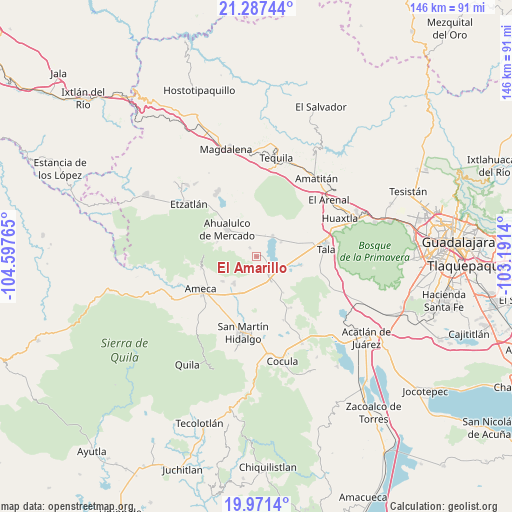
El Amarillo GPS coordinates[2]
20° 37' 51.024" North, 103° 53' 40.272" West
| Map corner | latitude | longitude |
|---|---|---|
| Upper-left | 21.28744°, | -104.59765° |
| Center: | 20.63084°, | -103.89452° |
| Lower-right: | 19.9714°, | -103.1914° |
| Map W x H: | 146.3×146.3 km | = 90.9×90.9mi |
| max Lat: | 32.7° ⇑29.4% North |
| El Amarillo: | 20.63084° |
| min Lat: | ⇓70.6% South 14.53588° |
| min Long | El Amarillo | max Long |
| -117.105° | -103.89452° | -86.73105° |
| W 10.3%⇐ | ⇒89.7% E |
Elevation
Elevation of El Amarillo is 1279 m = 4196 ft, and this is 25.3 m = 83 ft above average elevation for this country.
| Max E: |
3497 m = 11473 ft | 53.3% |
| El Amarillo | 1279 m 4196 ft | |
| Avg. | 1253.7 m = 4113 ft | |
Min E: |
-1 m = -3 ft | 46.7% |
See also: Mexico elevation on elevation.city.
Geographical zone
El Amarillo is located in North Torrid zone (between Equator and Tropic of Cancer). Distance of this Northern Tropic circle is 312 km =193.9 mi to North.| Distance of | km | miles | from El Amarillo |
|---|---|---|---|
| North Pole | 7713.1 | 4792.7 | to North |
| Arctic Circle | 5107.2 | 3173.5 | to North |
| Tropic Cancer | 312 | 193.9 | to North |
| Equator | 2293.9 | 1425.4 | to South |


Nearby cities:
15 places around El Amarillo: (largest is in red/bold)
• Ahualulco de Mercado
11.4 km =7.1 mi,  313°
313°
• Buenavista
8.3 km =5.2 mi,  147°
147°
• Castro Urdiales
8.6 km =5.3 mi,  115°
115°
• Cuisillos
12.7 km =7.9 mi,  100°
100°
• El Carmen
3.2 km =2 mi,  325°
325°
• El Ranchito (San Isidro)
12 km =7.5 mi,  105°
105°
• La Estanzuela
8.3 km =5.2 mi,  59°
59°
• La Vega
6.5 km =4 mi,  144°
144°
• Labor de Solís
11.8 km =7.3 mi,  233°
233°
• Los Pocitos
11.3 km =7 mi,  203°
203°
• Portes Gil
5.5 km =3.4 mi,  303°
303°
• Punta de la Vega
4.5 km =2.8 mi,  185°
185°
• Santa Cruz de Bárcenas
11.9 km =7.4 mi,  290°
290°
• Teuchitlán
7.6 km =4.7 mi,  38°
38°
• Trapiche de Abra
12.8 km =8 mi, 142°
Sources, notices
• [Note1] Compared only with cities in Mexico existing in our database
• [Src1] Map data: © OpenStreetMap contributors (CC-BY-SA)
• [Src2] Other city data from geonames.org with taken over terms of usage.
• [Src3] Geographical zone / Annual Mean Temperature by Robert A. Rohde @ Wikipedia
