El Ranchito (San Isidro) geodata
El Ranchito (San Isidro) (Jalisco) is a populated place; located in Mexico in America/Mexico_City (GMT-6) time zone. With population of 566 people, there are 15096 cities with bigger population in this country. Compared to other cities in Mexico, 70% of cities are located further ↓South; 89.4% of cities are located further →East and 53.4% of cities have higher elevation than El Ranchito (San Isidro). Note1
Current local time in El Ranchito (San Isidro):
08:29 AM, WednesdayDifference from your time zone: hours


El Ranchito (San Isidro) GPS coordinates[2]
20° 36' 5.004" North, 103° 47' 2.004" West
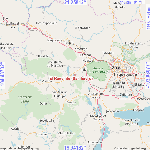
| Map corner | latitude | longitude |
|---|---|---|
| Upper-left | 21.25812°, | -104.48702° |
| Center: | 20.60139°, | -103.78389° |
| Lower-right: | 19.94182°, | -103.08077° |
| Map W x H: | 146.4×146.4 km | = 91×91mi |
| max Lat: | 32.7° ⇑30% North |
| El Ranchito (San Isidro): | 20.60139° |
| min Lat: | ⇓70% South 14.53588° |
| min Long | El Ranchito (Sa | max Long |
| -117.105° | -103.78389° | -86.73105° |
| W 10.6%⇐ | ⇒89.4% E |
Elevation
Elevation of El Ranchito (San Isidro) is 1274 m = 4180 ft, and this is 20.3 m = 67 ft above average elevation for this country.
| Max E: |
3497 m = 11473 ft | 53.4% |
| El Ranchito (San Isidro) | 1274 m 4180 ft | |
| Avg. | 1253.7 m = 4113 ft | |
Min E: |
-1 m = -3 ft | 46.6% |
See also: Mexico elevation on elevation.city.
Geographical zone
El Ranchito (San Isidro) is located in North Torrid zone (between Equator and Tropic of Cancer). Distance of this Northern Tropic circle is 315.3 km =195.9 mi to North.| Distance of | km | miles | from El Ranchito (San Isidro) |
|---|---|---|---|
| North Pole | 7716.4 | 4794.7 | to North |
| Arctic Circle | 5110.5 | 3175.5 | to North |
| Tropic Cancer | 315.3 | 195.9 | to North |
| Equator | 2290.7 | 1423.4 | to South |


Nearby cities:
15 places around El Ranchito (San Isidro): (largest is in red/bold)
• Ahuisculco
9.2 km =5.7 mi,  113°
113°
• Buenavista
8 km =5 mi,  242°
242°
• Camichinas
11.4 km =7.1 mi,  188°
188°
• Castro Urdiales
3.8 km =2.4 mi,  263°
263°
• Cuisillos
1.3 km =0.8 mi,  47°
47°
• El Amarillo
12 km =7.5 mi,  285°
285°
• El Refugio
9.1 km =5.7 mi,  30°
30°
• El Salitre
12.7 km =7.9 mi,  217°
217°
• La Estanzuela
8.7 km =5.4 mi,  329°
329°
• La Vega
8 km =5 mi, 255°
• Punta de la Vega
12 km =7.5 mi, 264°
• San Juan de los Arcos
6.7 km =4.2 mi,  86°
86°
• Tala
10.4 km =6.5 mi,  56°
56°
• Teuchitlán
11.5 km =7.1 mi,  323°
323°
• Trapiche de Abra
7.8 km =4.8 mi,  208°
208°
Sources, notices
• [Note1] Compared only with cities in Mexico existing in our database
• [Src1] Map data: © OpenStreetMap contributors (CC-BY-SA)
• [Src2] Other city data from geonames.org with taken over terms of usage.
• [Src3] Geographical zone / Annual Mean Temperature by Robert A. Rohde @ Wikipedia
