La Caja geodata
La Caja (Colima) is a populated place; located in Mexico in America/Mexico_City (GMT-6) time zone. With population of 717 people, there are 12151 cities with bigger population in this country. Compared to other cities in Mexico, 57% of cities are located further ↑North; 89.4% of cities are located further →East and 65.6% of cities have higher elevation than La Caja. Note1


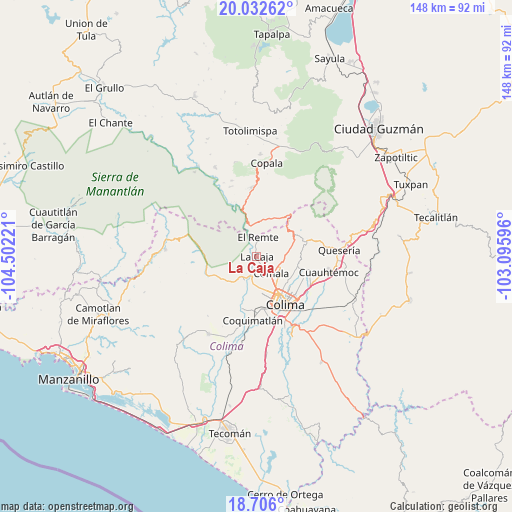
La Caja GPS coordinates[2]
19° 22' 14.376" North, 103° 47' 56.688" West
| Map corner | latitude | longitude |
|---|---|---|
| Upper-left | 20.03262°, | -104.50221° |
| Center: | 19.37066°, | -103.79908° |
| Lower-right: | 18.706°, | -103.09596° |
| Map W x H: | 147.5×147.5 km | = 91.7×91.7mi |
| max Lat: | 32.7° ⇑57% North |
| La Caja: | 19.37066° |
| min Lat: | ⇓43% South 14.53588° |
| min Long | La Caja | max Long |
| -117.105° | -103.79908° | -86.73105° |
| W 10.6%⇐ | ⇒89.4% E |
Elevation
Elevation of La Caja is 656 m = 2152 ft, and this is 597.7 m = 1961 ft below average elevation for this country.
| Max E: |
3497 m = 11473 ft | 65.6% |
| Avg. | 1253.7 m = 4113 ft | |
| La Caja | 656 m = 2152 ft | |
Min E: |
-1 m = -3 ft | 34.4% |
See also: Mexico elevation on elevation.city.
Geographical zone
La Caja is located in North Torrid zone (between Equator and Tropic of Cancer). Distance of this Northern Tropic circle is 452.1 km =280.9 mi to North.| Distance of | km | miles | from La Caja |
|---|---|---|---|
| North Pole | 7853.2 | 4879.8 | to North |
| Arctic Circle | 5247.4 | 3260.6 | to North |
| Tropic Cancer | 452.1 | 280.9 | to North |
| Equator | 2153.8 | 1338.3 | to South |


Nearby cities:
15 places around La Caja: (largest is in red/bold)
• Chiapa
15.7 km =9.8 mi,  103°
103°
• Ciudad de Villa de Álvarez
13.2 km =8.2 mi,  150°
150°
• Cofradía de Suchitlán
11.2 km =7 mi,  67°
67°
• Colima
15.4 km =9.6 mi, 150°
• Comala
6.4 km =4 mi,  139°
139°
• Coquimatlán
18.3 km =11.4 mi,  183°
183°
• Cuauhtémoc
21.1 km =13.1 mi, 102°
• El Chanal
12.9 km =8 mi,  130°
130°
• El Trapiche
17.8 km =11.1 mi, 125°
• La Esperanza
23.1 km =14.4 mi,  197°
197°
• Ocotillo
16.2 km =10.1 mi, 104°
• San José del Carmen
10.9 km =6.8 mi,  19°
19°
• Suchitlán
9.2 km =5.7 mi,  86°
86°
• Zacualpan
2.8 km =1.7 mi,  252°
252°
• Zapotitlán de Vadillo
19.9 km =12.4 mi,  356°
356°
Sources, notices
• [Note1] Compared only with cities in Mexico existing in our database
• [Src1] Map data: © OpenStreetMap contributors (CC-BY-SA)
• [Src2] Other city data from geonames.org with taken over terms of usage.
• [Src3] Geographical zone / Annual Mean Temperature by Robert A. Rohde @ Wikipedia
