Buenavista geodata
Buenavista (State of Mexico) is a populated place; located in Mexico in America/Mexico_City (GMT-6) time zone. With population of 2,536 people, there are 3498 cities with bigger population in this country. Compared to other cities in Mexico, 55.4% of cities are located further ↓South; 66.7% of cities are located further →East and 84.9% of cities have lower elevation than Buenavista. Note1


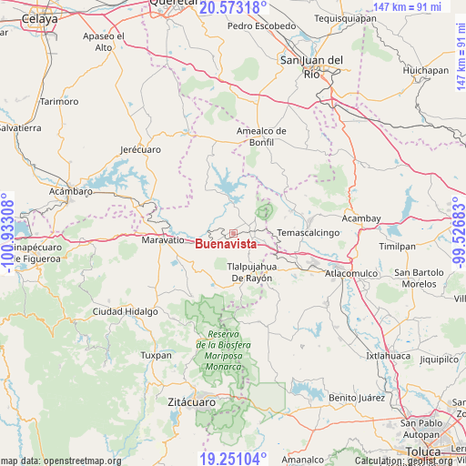
Buenavista GPS coordinates[2]
19° 54' 48.564" North, 100° 13' 47.82" West
| Map corner | latitude | longitude |
|---|---|---|
| Upper-left | 20.57318°, | -100.93308° |
| Center: | 19.91349°, | -100.22995° |
| Lower-right: | 19.25104°, | -99.52683° |
| Map W x H: | 147×147 km | = 91.3×91.3mi |
| max Lat: | 32.7° ⇑44.6% North |
| Buenavista: | 19.91349° |
| min Lat: | ⇓55.4% South 14.53588° |
| min Long | Buenavista | max Long |
| -117.105° | -100.22995° | -86.73105° |
| W 33.3%⇐ | ⇒66.7% E |
Elevation
Elevation of Buenavista is 2257 m = 7405 ft, and this is 1003.3 m = 3292 ft above average elevation for this country.
| Max E: |
3497 m = 11473 ft | 15.1% |
| Buenavista | 2257 m 7405 ft | |
| Avg. | 1253.7 m = 4113 ft | |
Min E: |
-1 m = -3 ft | 84.9% |
See also: Mexico elevation on elevation.city.
Geographical zone
Buenavista is located in North Torrid zone (between Equator and Tropic of Cancer). Distance of this Northern Tropic circle is 391.7 km =243.4 mi to North.| Distance of | km | miles | from Buenavista |
|---|---|---|---|
| North Pole | 7792.9 | 4842.3 | to North |
| Arctic Circle | 5187 | 3223.1 | to North |
| Tropic Cancer | 391.7 | 243.4 | to North |
| Equator | 2214.2 | 1375.8 | to South |


Nearby cities:
15 places around Buenavista: (largest is in red/bold)
• Agua Caliente
6.3 km =3.9 mi,  103°
103°
• Atotonilco
3.2 km =2 mi,  13°
13°
• Contepec
8.3 km =5.2 mi,  56°
56°
• El Capulín
9.1 km =5.7 mi,  116°
116°
• El Césped
10 km =6.2 mi,  110°
110°
• El Encino
6.4 km =4 mi,  90°
90°
• El Gigante
8 km =5 mi,  152°
152°
• La Higuerilla (Los Lirios)
5 km =3.1 mi,  281°
281°
• La Huerta
7.4 km =4.6 mi,  226°
226°
• Las Tenerías (Las Tenerías de Tepetongo)
11.2 km =7 mi, 95°
• San Miguel el Alto (El Puerto)
8.1 km =5 mi,  201°
201°
• San Ramón
3.3 km =2.1 mi,  242°
242°
• Tepetongo
10.1 km =6.3 mi, 92°
• Tepuxtepec
8.7 km =5.4 mi,  2°
2°
• Venta de Bravo
8.1 km =5 mi,  132°
132°
Sources, notices
• [Note1] Compared only with cities in Mexico existing in our database
• [Src1] Map data: © OpenStreetMap contributors (CC-BY-SA)
• [Src2] Other city data from geonames.org with taken over terms of usage.
• [Src3] Geographical zone / Annual Mean Temperature by Robert A. Rohde @ Wikipedia
