Chiapa geodata
Chiapa (Colima) is a populated place; located in Mexico in America/Mexico_City (GMT-6) time zone. With population of 882 people, there are 9904 cities with bigger population in this country. Compared to other cities in Mexico, 57.9% of cities are located further ↑North; 88.9% of cities are located further →East and 61.5% of cities have higher elevation than Chiapa. Note1


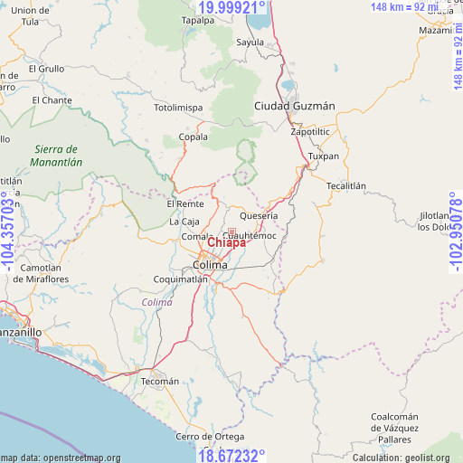
Chiapa GPS coordinates[2]
19° 20' 13.596" North, 103° 39' 14.04" West
| Map corner | latitude | longitude |
|---|---|---|
| Upper-left | 19.99921°, | -104.35703° |
| Center: | 19.33711°, | -103.6539° |
| Lower-right: | 18.67232°, | -102.95078° |
| Map W x H: | 147.5×147.5 km | = 91.7×91.7mi |
| max Lat: | 32.7° ⇑57.9% North |
| Chiapa: | 19.33711° |
| min Lat: | ⇓42.1% South 14.53588° |
| min Long | Chiapa | max Long |
| -117.105° | -103.6539° | -86.73105° |
| W 11.1%⇐ | ⇒88.9% E |
Elevation
Elevation of Chiapa is 909 m = 2982 ft, and this is 344.7 m = 1131 ft below average elevation for this country.
| Max E: |
3497 m = 11473 ft | 61.5% |
| Avg. | 1253.7 m = 4113 ft | |
| Chiapa | 909 m = 2982 ft | |
Min E: |
-1 m = -3 ft | 38.5% |
See also: Mexico elevation on elevation.city.
Geographical zone
Chiapa is located in North Torrid zone (between Equator and Tropic of Cancer). Distance of this Northern Tropic circle is 455.8 km =283.2 mi to North.| Distance of | km | miles | from Chiapa |
|---|---|---|---|
| North Pole | 7857 | 4882.1 | to North |
| Arctic Circle | 5251.1 | 3262.9 | to North |
| Tropic Cancer | 455.8 | 283.2 | to North |
| Equator | 2150.1 | 1336 | to South |


Nearby cities:
15 places around Chiapa: (largest is in red/bold)
• Alcaraces
8.6 km =5.3 mi,  69°
69°
• Alzada
15.7 km =9.8 mi,  123°
123°
• Buenavista
10.6 km =6.6 mi,  155°
155°
• Ciudad de Villa de Álvarez
11.7 km =7.3 mi,  228°
228°
• Cofradía
15.3 km =9.5 mi,  45°
45°
• Cofradía de Suchitlán
9.4 km =5.8 mi,  328°
328°
• Colima
12.4 km =7.7 mi,  218°
218°
• Comala
11.1 km =6.9 mi,  264°
264°
• Cuauhtémoc
5.4 km =3.4 mi,  100°
100°
• El Chanal
7.2 km =4.5 mi, 229°
• El Trapiche
6.6 km =4.1 mi,  186°
186°
• Ocotillo
0.6 km =0.4 mi,  135°
135°
• Palmillas
10.9 km =6.8 mi,  81°
81°
• Quesería
10.2 km =6.3 mi,  56°
56°
• Suchitlán
7.4 km =4.6 mi,  305°
305°
Sources, notices
• [Note1] Compared only with cities in Mexico existing in our database
• [Src1] Map data: © OpenStreetMap contributors (CC-BY-SA)
• [Src2] Other city data from geonames.org with taken over terms of usage.
• [Src3] Geographical zone / Annual Mean Temperature by Robert A. Rohde @ Wikipedia
