Cuauhtémoc geodata
Cuauhtémoc (Colima) is a seat of a second-order administrative division; located in Mexico in America/Mexico_City (GMT-6) time zone. With population of 8,602 people, there are 1108 cities with bigger population in this country. Compared to other cities in Mexico, 58.1% of cities are located further ↑North; 88.7% of cities are located further →East and 60.9% of cities have higher elevation than Cuauhtémoc. Note1


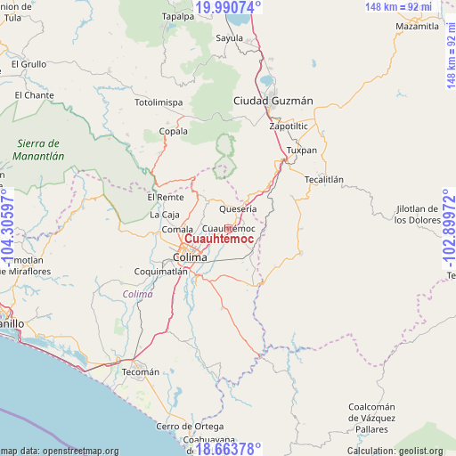
Cuauhtémoc GPS coordinates[2]
19° 19' 42.996" North, 103° 36' 10.224" West
| Map corner | latitude | longitude |
|---|---|---|
| Upper-left | 19.99074°, | -104.30597° |
| Center: | 19.32861°, | -103.60284° |
| Lower-right: | 18.66378°, | -102.89972° |
| Map W x H: | 147.5×147.5 km | = 91.7×91.7mi |
| max Lat: | 32.7° ⇑58.1% North |
| Cuauhtémoc: | 19.32861° |
| min Lat: | ⇓41.9% South 14.53588° |
| min Long | Cuauhtémoc | max Long |
| -117.105° | -103.60284° | -86.73105° |
| W 11.3%⇐ | ⇒88.7% E |
Elevation
Elevation of Cuauhtémoc is 946 m = 3104 ft, and this is 307.7 m = 1010 ft below average elevation for this country.
| Max E: |
3497 m = 11473 ft | 60.9% |
| Avg. | 1253.7 m = 4113 ft | |
| Cuauhtémoc | 946 m = 3104 ft | |
Min E: |
-1 m = -3 ft | 39.1% |
See also: Mexico elevation on elevation.city.
Geographical zone
Cuauhtémoc is located in North Torrid zone (between Equator and Tropic of Cancer). Distance of this Northern Tropic circle is 456.8 km =283.8 mi to North.| Distance of | km | miles | from Cuauhtémoc |
|---|---|---|---|
| North Pole | 7857.9 | 4882.7 | to North |
| Arctic Circle | 5252 | 3263.4 | to North |
| Tropic Cancer | 456.8 | 283.8 | to North |
| Equator | 2149.1 | 1335.4 | to South |


Nearby cities:
15 places around Cuauhtémoc: (largest is in red/bold)
• Alcaraces
4.8 km =3 mi,  34°
34°
• Alzada
11 km =6.8 mi,  135°
135°
• Buenavista
8.7 km =5.4 mi,  185°
185°
• Chiapa
5.4 km =3.4 mi,  280°
280°
• Ciudad de Villa de Álvarez
15.7 km =9.8 mi,  244°
244°
• Cofradía
12.9 km =8 mi, 25°
• Cofradía de Suchitlán
13.6 km =8.5 mi,  311°
311°
• Colima
15.7 km =9.8 mi, 236°
• El Chanal
11.4 km =7.1 mi,  250°
250°
• El Trapiche
8.3 km =5.2 mi,  227°
227°
• Ocotillo
5 km =3.1 mi, 276°
• Palmillas
6 km =3.7 mi,  64°
64°
• Quesería
7.2 km =4.5 mi, 26°
• Suchitlán
12.5 km =7.8 mi,  294°
294°
• Tonila
14.8 km =9.2 mi,  37°
37°
Sources, notices
• [Note1] Compared only with cities in Mexico existing in our database
• [Src1] Map data: © OpenStreetMap contributors (CC-BY-SA)
• [Src2] Other city data from geonames.org with taken over terms of usage.
• [Src3] Geographical zone / Annual Mean Temperature by Robert A. Rohde @ Wikipedia
