Chucándiro geodata
Chucándiro (Michoacán) is a seat of a second-order administrative division; located in Mexico in America/Mexico_City (GMT-6) time zone. With population of 1,609 people, there are 5377 cities with bigger population in this country. Compared to other cities in Mexico, 55.1% of cities are located further ↓South; 75.9% of cities are located further →East and 66.5% of cities have lower elevation than Chucándiro. Note1


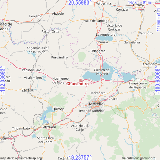
Chucándiro GPS coordinates[2]
19° 54' 0.288" North, 101° 20' 1.68" West
| Map corner | latitude | longitude |
|---|---|---|
| Upper-left | 20.55983°, | -102.03693° |
| Center: | 19.90008°, | -101.3338° |
| Lower-right: | 19.23757°, | -100.63068° |
| Map W x H: | 147×147 km | = 91.3×91.3mi |
| max Lat: | 32.7° ⇑44.9% North |
| Chucándiro: | 19.90008° |
| min Lat: | ⇓55.1% South 14.53588° |
| min Long | Chucándiro | max Long |
| -117.105° | -101.3338° | -86.73105° |
| W 24.1%⇐ | ⇒75.9% E |
Elevation
Elevation of Chucándiro is 1861 m = 6106 ft, and this is 607.3 m = 1992 ft above average elevation for this country.
| Max E: |
3497 m = 11473 ft | 33.5% |
| Chucándiro | 1861 m 6106 ft | |
| Avg. | 1253.7 m = 4113 ft | |
Min E: |
-1 m = -3 ft | 66.5% |
See also: Mexico elevation on elevation.city.
Geographical zone
Chucándiro is located in North Torrid zone (between Equator and Tropic of Cancer). Distance of this Northern Tropic circle is 393.2 km =244.3 mi to North.| Distance of | km | miles | from Chucándiro |
|---|---|---|---|
| North Pole | 7794.4 | 4843.2 | to North |
| Arctic Circle | 5188.5 | 3224 | to North |
| Tropic Cancer | 393.2 | 244.3 | to North |
| Equator | 2212.7 | 1374.9 | to South |


Nearby cities:
15 places around Chucándiro: (largest is in red/bold)
• Capacho
12.9 km =8 mi,  56°
56°
• Cañada de la Yerbabuena
13.7 km =8.5 mi,  105°
105°
• Cañada de los Sauces
14.5 km =9 mi,  121°
121°
• Chiquimitío
14.5 km =9 mi,  143°
143°
• Copándaro de Galeana
12.6 km =7.8 mi,  93°
93°
• Cotzurio
10.8 km =6.7 mi,  159°
159°
• El Nispo
11.5 km =7.1 mi,  97°
97°
• El Salitre
2.1 km =1.3 mi, 95°
• Huandacareo
11.8 km =7.3 mi,  30°
30°
• La Estancia
9.2 km =5.7 mi,  19°
19°
• San José Cuaro
13 km =8.1 mi,  41°
41°
• San Nicolás Tumbastatiro (Cañada de Abajo)
10.7 km =6.6 mi,  355°
355°
• Santa Rita
7.5 km =4.7 mi, 86°
• Tendeparacua
10.3 km =6.4 mi,  267°
267°
• Villa Morelos
14.2 km =8.8 mi,  324°
324°
Sources, notices
• [Note1] Compared only with cities in Mexico existing in our database
• [Src1] Map data: © OpenStreetMap contributors (CC-BY-SA)
• [Src2] Other city data from geonames.org with taken over terms of usage.
• [Src3] Geographical zone / Annual Mean Temperature by Robert A. Rohde @ Wikipedia
