Villa Morelos geodata
Villa Morelos (State of Mexico) is a populated place; located in Mexico in America/Mexico_City (GMT-6) time zone. With population of 2,446 people, there are 3611 cities with bigger population in this country. Compared to other cities in Mexico, 57% of cities are located further ↓South; 76.6% of cities are located further →East and 86.3% of cities have lower elevation than Villa Morelos. Note1


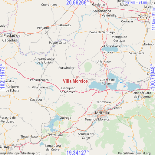
Villa Morelos GPS coordinates[2]
20° 0' 12.06" North, 101° 24' 48.96" West
| Map corner | latitude | longitude |
|---|---|---|
| Upper-left | 20.66266°, | -102.11673° |
| Center: | 20.00335°, | -101.4136° |
| Lower-right: | 19.34127°, | -100.71048° |
| Map W x H: | 146.9×146.9 km | = 91.3×91.3mi |
| max Lat: | 32.7° ⇑43% North |
| Villa Morelos: | 20.00335° |
| min Lat: | ⇓57% South 14.53588° |
| min Long | Villa Morelos | max Long |
| -117.105° | -101.4136° | -86.73105° |
| W 23.4%⇐ | ⇒76.6% E |
Elevation
Elevation of Villa Morelos is 2290 m = 7513 ft, and this is 1036.3 m = 3400 ft above average elevation for this country.
| Max E: |
3497 m = 11473 ft | 13.7% |
| Villa Morelos | 2290 m 7513 ft | |
| Avg. | 1253.7 m = 4113 ft | |
Min E: |
-1 m = -3 ft | 86.3% |
See also: Mexico elevation on elevation.city.
Geographical zone
Villa Morelos is located in North Torrid zone (between Equator and Tropic of Cancer). Distance of this Northern Tropic circle is 381.8 km =237.2 mi to North.| Distance of | km | miles | from Villa Morelos |
|---|---|---|---|
| North Pole | 7782.9 | 4836.1 | to North |
| Arctic Circle | 5177 | 3216.8 | to North |
| Tropic Cancer | 381.8 | 237.2 | to North |
| Equator | 2224.2 | 1382.1 | to South |


Nearby cities:
15 places around Villa Morelos: (largest is in red/bold)
• Batuecas
7.9 km =4.9 mi,  301°
301°
• Cerano
12 km =7.5 mi,  13°
13°
• Cerécuaro
8.8 km =5.5 mi,  53°
53°
• Chucándiro
14.2 km =8.8 mi,  144°
144°
• El Salitre
15.6 km =9.7 mi, 138°
• Galeana
16.9 km =10.5 mi,  282°
282°
• Huandacareo
14.4 km =8.9 mi,  95°
95°
• Huaniqueo de Morales
15.2 km =9.4 mi,  218°
218°
• La Barranca
9 km =5.6 mi,  340°
340°
• La Estancia
11.8 km =7.3 mi, 104°
• Las Tortugas (Emiliano Zapata)
15.2 km =9.4 mi,  359°
359°
• Ojos de Agua de Cerano
12.7 km =7.9 mi,  22°
22°
• Puruándiro
14.3 km =8.9 mi,  311°
311°
• San Nicolás Tumbastatiro (Cañada de Abajo)
7.5 km =4.7 mi, 96°
• Tendeparacua
12 km =7.5 mi,  189°
189°
Sources, notices
• [Note1] Compared only with cities in Mexico existing in our database
• [Src1] Map data: © OpenStreetMap contributors (CC-BY-SA)
• [Src2] Other city data from geonames.org with taken over terms of usage.
• [Src3] Geographical zone / Annual Mean Temperature by Robert A. Rohde @ Wikipedia
