Tendeparacua geodata
Tendeparacua (State of Mexico) is a populated place; located in Mexico in America/Mexico_City (GMT-6) time zone. With population of 562 people, there are 15183 cities with bigger population in this country. Compared to other cities in Mexico, 55% of cities are located further ↓South; 76.8% of cities are located further →East and 81.6% of cities have lower elevation than Tendeparacua. Note1


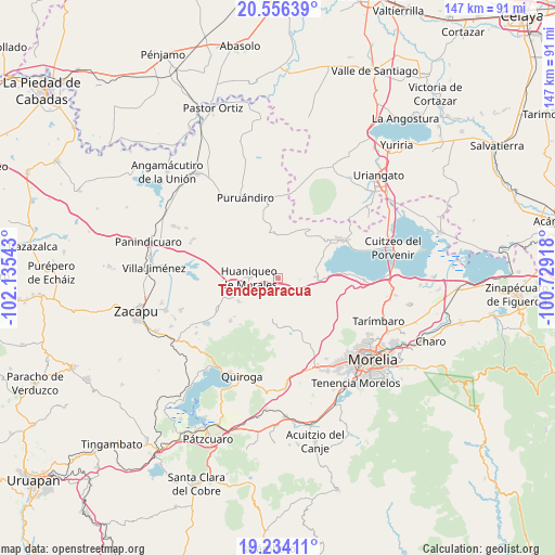
Tendeparacua GPS coordinates[2]
19° 53' 47.868" North, 101° 25' 56.28" West
| Map corner | latitude | longitude |
|---|---|---|
| Upper-left | 20.55639°, | -102.13543° |
| Center: | 19.89663°, | -101.4323° |
| Lower-right: | 19.23411°, | -100.72918° |
| Map W x H: | 147×147 km | = 91.3×91.3mi |
| max Lat: | 32.7° ⇑45% North |
| Tendeparacua: | 19.89663° |
| min Lat: | ⇓55% South 14.53588° |
| min Long | Tendeparacua | max Long |
| -117.105° | -101.4323° | -86.73105° |
| W 23.2%⇐ | ⇒76.8% E |
Elevation
Elevation of Tendeparacua is 2180 m = 7152 ft, and this is 926.3 m = 3039 ft above average elevation for this country.
| Max E: |
3497 m = 11473 ft | 18.4% |
| Tendeparacua | 2180 m 7152 ft | |
| Avg. | 1253.7 m = 4113 ft | |
Min E: |
-1 m = -3 ft | 81.6% |
See also: Mexico elevation on elevation.city.
Geographical zone
Tendeparacua is located in North Torrid zone (between Equator and Tropic of Cancer). Distance of this Northern Tropic circle is 393.6 km =244.6 mi to North.| Distance of | km | miles | from Tendeparacua |
|---|---|---|---|
| North Pole | 7794.8 | 4843.5 | to North |
| Arctic Circle | 5188.9 | 3224.2 | to North |
| Tropic Cancer | 393.6 | 244.6 | to North |
| Equator | 2212.3 | 1374.7 | to South |


Nearby cities:
15 places around Tendeparacua: (largest is in red/bold)
• Aracurio
14.2 km =8.8 mi,  195°
195°
• Batuecas
16.7 km =10.4 mi,  343°
343°
• Chucándiro
10.3 km =6.4 mi,  87°
87°
• Cotzurio
17 km =10.6 mi,  124°
124°
• El Salitre
12.4 km =7.7 mi, 89°
• Huaniqueo de Morales
7.5 km =4.7 mi,  270°
270°
• La Cañada
12.1 km =7.5 mi,  239°
239°
• La Estancia
16.2 km =10.1 mi,  56°
56°
• San Isidro
15.2 km =9.4 mi,  249°
249°
• San Nicolás Tumbastatiro (Cañada de Abajo)
14.5 km =9 mi,  40°
40°
• Santa Rita
17.8 km =11.1 mi, 87°
• Tecacho
7.1 km =4.4 mi,  216°
216°
• Teremendo
13.3 km =8.3 mi, 201°
• Villa Morelos
12 km =7.5 mi,  9°
9°
• Zipiajo
16.9 km =10.5 mi,  227°
227°
Sources, notices
• [Note1] Compared only with cities in Mexico existing in our database
• [Src1] Map data: © OpenStreetMap contributors (CC-BY-SA)
• [Src2] Other city data from geonames.org with taken over terms of usage.
• [Src3] Geographical zone / Annual Mean Temperature by Robert A. Rohde @ Wikipedia
