La Estancia geodata
La Estancia (Michoacán) is a populated place; located in Mexico in America/Mexico_City (GMT-6) time zone. With population of 851 people, there are 10275 cities with bigger population in this country. Compared to other cities in Mexico, 56.5% of cities are located further ↓South; 75.7% of cities are located further →East and 66.4% of cities have lower elevation than La Estancia. Note1


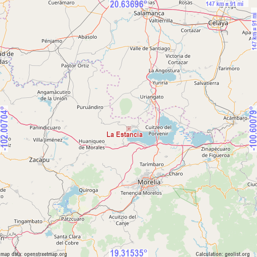
La Estancia GPS coordinates[2]
19° 58' 39.144" North, 101° 18' 14.076" West
| Map corner | latitude | longitude |
|---|---|---|
| Upper-left | 20.63696°, | -102.00704° |
| Center: | 19.97754°, | -101.30391° |
| Lower-right: | 19.31535°, | -100.60079° |
| Map W x H: | 146.9×147 km | = 91.3×91.3mi |
| max Lat: | 32.7° ⇑43.5% North |
| La Estancia: | 19.97754° |
| min Lat: | ⇓56.5% South 14.53588° |
| min Long | La Estancia | max Long |
| -117.105° | -101.30391° | -86.73105° |
| W 24.3%⇐ | ⇒75.7% E |
Elevation
Elevation of La Estancia is 1859 m = 6099 ft, and this is 605.3 m = 1986 ft above average elevation for this country.
| Max E: |
3497 m = 11473 ft | 33.6% |
| La Estancia | 1859 m 6099 ft | |
| Avg. | 1253.7 m = 4113 ft | |
Min E: |
-1 m = -3 ft | 66.4% |
See also: Mexico elevation on elevation.city.
Geographical zone
La Estancia is located in North Torrid zone (between Equator and Tropic of Cancer). Distance of this Northern Tropic circle is 384.6 km =239 mi to North.| Distance of | km | miles | from La Estancia |
|---|---|---|---|
| North Pole | 7785.8 | 4837.9 | to North |
| Arctic Circle | 5179.9 | 3218.6 | to North |
| Tropic Cancer | 384.6 | 239 | to North |
| Equator | 2221.3 | 1380.3 | to South |


Nearby cities:
15 places around La Estancia: (largest is in red/bold)
• Capacho
7.7 km =4.8 mi,  100°
100°
• Cerécuaro
9.2 km =5.7 mi,  331°
331°
• Chucándiro
9.2 km =5.7 mi,  199°
199°
• Copándaro de Galeana
13.3 km =8.3 mi,  135°
135°
• Doctor Miguel Silva (San Guillermo)
13.6 km =8.5 mi, 95°
• El Nispo
13 km =8.1 mi, 140°
• El Salitre
8.9 km =5.5 mi,  186°
186°
• Huandacareo
3.3 km =2.1 mi,  62°
62°
• Jéruco
14.1 km =8.8 mi,  92°
92°
• La Ordeña
13.8 km =8.6 mi,  11°
11°
• Piñícuaro
10.2 km =6.3 mi,  40°
40°
• San José Cuaro
5.6 km =3.5 mi,  77°
77°
• San Nicolás Tumbastatiro (Cañada de Abajo)
4.5 km =2.8 mi,  297°
297°
• Santa Rita
9.2 km =5.7 mi,  151°
151°
• Villa Morelos
11.8 km =7.3 mi,  284°
284°
Sources, notices
• [Note1] Compared only with cities in Mexico existing in our database
• [Src1] Map data: © OpenStreetMap contributors (CC-BY-SA)
• [Src2] Other city data from geonames.org with taken over terms of usage.
• [Src3] Geographical zone / Annual Mean Temperature by Robert A. Rohde @ Wikipedia
