Chinobampo geodata
Chinobampo (Sinaloa) is a populated place; located in Mexico in America/Mazatlan (GMT-7) time zone. With population of 1,495 people, there are 5773 cities with bigger population in this country. Compared to other cities in Mexico, 95.7% of cities are located further ↓South; 96% of cities are located further →East and 73% of cities have higher elevation than Chinobampo. Note1


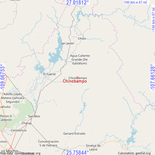
Chinobampo GPS coordinates[2]
26° 23' 24" North, 108° 21' 51.84" West
| Map corner | latitude | longitude |
|---|---|---|
| Upper-left | 27.01812°, | -109.06753° |
| Center: | 26.39°, | -108.3644° |
| Lower-right: | 25.75844°, | -107.66128° |
| Map W x H: | 140.1×140.1 km | = 87.1×87.1mi |
| max Lat: | 32.7° ⇑4.3% North |
| Chinobampo: | 26.39° |
| min Lat: | ⇓95.7% South 14.53588° |
| min Long | Chinobampo | max Long |
| -117.105° | -108.3644° | -86.73105° |
| W 4%⇐ | ⇒96% E |
Elevation
Elevation of Chinobampo is 287 m = 942 ft, and this is 966.7 m = 3172 ft below average elevation for this country.
| Max E: |
3497 m = 11473 ft | 73% |
| Avg. | 1253.7 m = 4113 ft | |
| Chinobampo | 287 m = 942 ft | |
Min E: |
-1 m = -3 ft | 27% |
See also: Mexico elevation on elevation.city.
Geographical zone
Chinobampo is located in North temperate zone (between Tropic of Cancer and the Arctic Circle). Distance of this Northern Tropic circle is 328.4 km =204.1 mi to South.| Distance of | km | miles | from Chinobampo |
|---|---|---|---|
| North Pole | 7072.8 | 4394.8 | to North |
| Arctic Circle | 4466.9 | 2775.6 | to North |
| Tropic Cancer | 328.4 | 204.1 | to South |
| Equator | 2934.3 | 1823.3 | to South |


Nearby cities:
15 places around Chinobampo: (largest is in red/bold)
• Agua Caliente Grande (De Gastélum)
16.5 km =10.3 mi,  5°
5°
• Bajosori
33.2 km =20.6 mi,  354°
354°
• Baroten
28.9 km =18 mi,  272°
272°
• Boca de Arroyo
39.7 km =24.7 mi,  258°
258°
• Choix
35.7 km =22.2 mi, 6°
• El Canutillo
26 km =16.2 mi, 266°
• El Fuerte
25.5 km =15.8 mi,  276°
276°
• Estación Hoyancos (Estación el Fuerte)
23 km =14.3 mi, 263°
• Guadalupe
26.1 km =16.2 mi, 9°
• La Bajada del Monte
34 km =21.1 mi, 259°
• Los Capomos
15.6 km =9.7 mi, 284°
• San Javier
32.8 km =20.4 mi,  343°
343°
• San Pedro
18.3 km =11.4 mi,  323°
323°
• Santa Ana
22.3 km =13.9 mi, 354°
• Tehueco
39.4 km =24.5 mi,  254°
254°
Sources, notices
• [Note1] Compared only with cities in Mexico existing in our database
• [Src1] Map data: © OpenStreetMap contributors (CC-BY-SA)
• [Src2] Other city data from geonames.org with taken over terms of usage.
• [Src3] Geographical zone / Annual Mean Temperature by Robert A. Rohde @ Wikipedia
