Ceballos geodata
Ceballos (Durango) is a populated place; located in Mexico in America/Monterrey (GMT-6) time zone. With population of 3,730 people, there are 2461 cities with bigger population in this country. Compared to other cities in Mexico, 95.8% of cities are located further ↓South; 90.3% of cities are located further →East and 55.3% of cities have higher elevation than Ceballos. Note1


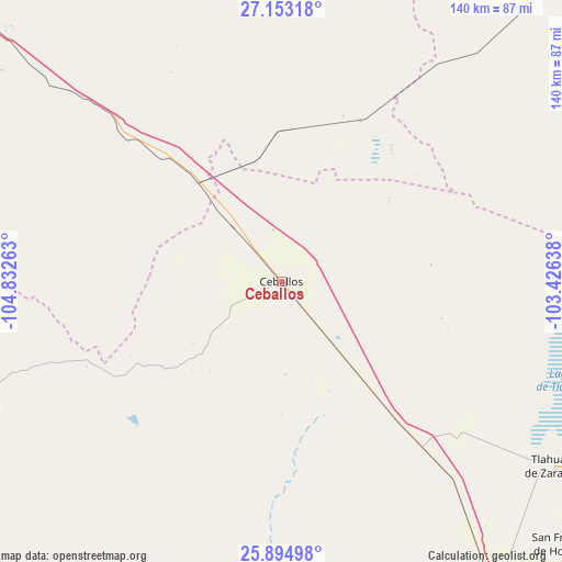
Ceballos GPS coordinates[2]
26° 31' 32.88" North, 104° 7' 46.2" West
| Map corner | latitude | longitude |
|---|---|---|
| Upper-left | 27.15318°, | -104.83263° |
| Center: | 26.5258°, | -104.1295° |
| Lower-right: | 25.89498°, | -103.42638° |
| Map W x H: | 139.9×139.9 km | = 86.9×86.9mi |
| max Lat: | 32.7° ⇑4.2% North |
| Ceballos: | 26.5258° |
| min Lat: | ⇓95.8% South 14.53588° |
| min Long | Ceballos | max Long |
| -117.105° | -104.1295° | -86.73105° |
| W 9.7%⇐ | ⇒90.3% E |
Elevation
Elevation of Ceballos is 1186 m = 3891 ft, and this is 67.7 m = 222 ft below average elevation for this country.
| Max E: |
3497 m = 11473 ft | 55.3% |
| Avg. | 1253.7 m = 4113 ft | |
| Ceballos | 1186 m = 3891 ft | |
Min E: |
-1 m = -3 ft | 44.7% |
See also: Mexico elevation on elevation.city.
Geographical zone
Ceballos is located in North temperate zone (between Tropic of Cancer and the Arctic Circle). Distance of this Northern Tropic circle is 343.5 km =213.4 mi to South.| Distance of | km | miles | from Ceballos |
|---|---|---|---|
| North Pole | 7057.7 | 4385.5 | to North |
| Arctic Circle | 4451.8 | 2766.2 | to North |
| Tropic Cancer | 343.5 | 213.4 | to South |
| Equator | 2949.4 | 1832.7 | to South |


Nearby cities:
15 places around Ceballos: (largest is in red/bold)
• Bermejillo
87.3 km =54.2 mi,  144°
144°
• Chula Vista
95 km =59 mi,  52°
52°
• Escalón
32.8 km =20.4 mi,  319°
319°
• La Esmeralda
96.5 km =60 mi,  28°
28°
• Laguna del Rey (Químicas del Rey)
94.3 km =58.6 mi, 53°
• Mapimí
82 km =51 mi,  159°
159°
• Marta
96.3 km =59.8 mi,  148°
148°
• Pamplona
86.6 km =53.8 mi,  122°
122°
• San José de Bellavista
84 km =52.2 mi, 150°
• San Julio
96.4 km =59.9 mi,  132°
132°
• Santa Clara
96 km =59.7 mi, 146°
• Sierra Mojada
94.9 km =59 mi, 26°
• Tlahualilo de Zaragoza
82.9 km =51.5 mi, 124°
• Veintidós de Febrero
91.4 km =56.8 mi, 146°
• Villa Hidalgo
84 km =52.2 mi,  248°
248°
Sources, notices
• [Note1] Compared only with cities in Mexico existing in our database
• [Src1] Map data: © OpenStreetMap contributors (CC-BY-SA)
• [Src2] Other city data from geonames.org with taken over terms of usage.
• [Src3] Geographical zone / Annual Mean Temperature by Robert A. Rohde @ Wikipedia
