Samachique geodata
Samachique (Chihuahua) is a populated place; located in Mexico in America/Chihuahua (GMT-6) time zone. With population of 1,241 people, there are 6992 cities with bigger population in this country. Compared to other cities in Mexico, 96.7% of cities are located further ↓South; 95% of cities are located further →East and 80.1% of cities have lower elevation than Samachique. Note1


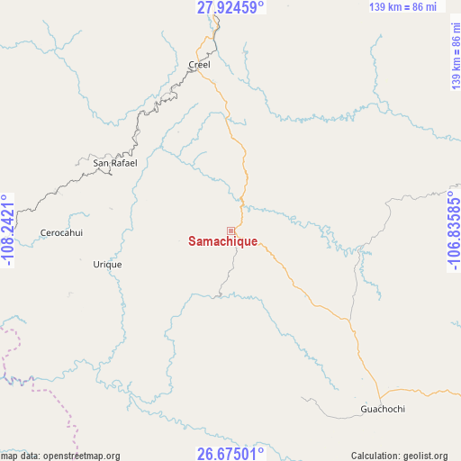
Samachique GPS coordinates[2]
27° 18' 5.616" North, 107° 32' 20.292" West
| Map corner | latitude | longitude |
|---|---|---|
| Upper-left | 27.92459°, | -108.2421° |
| Center: | 27.30156°, | -107.53897° |
| Lower-right: | 26.67501°, | -106.83585° |
| Map W x H: | 138.9×138.9 km | = 86.3×86.3mi |
| max Lat: | 32.7° ⇑3.3% North |
| Samachique: | 27.30156° |
| min Lat: | ⇓96.7% South 14.53588° |
| min Long | Samachique | max Long |
| -117.105° | -107.53897° | -86.73105° |
| W 5%⇐ | ⇒95% E |
Elevation
Elevation of Samachique is 2143 m = 7031 ft, and this is 889.3 m = 2918 ft above average elevation for this country.
| Max E: |
3497 m = 11473 ft | 19.9% |
| Samachique | 2143 m 7031 ft | |
| Avg. | 1253.7 m = 4113 ft | |
Min E: |
-1 m = -3 ft | 80.1% |
See also: Mexico elevation on elevation.city.
Geographical zone
Samachique is located in North temperate zone (between Tropic of Cancer and the Arctic Circle). Distance of this Northern Tropic circle is 429.7 km =267 mi to South.| Distance of | km | miles | from Samachique |
|---|---|---|---|
| North Pole | 6971.4 | 4331.8 | to North |
| Arctic Circle | 4365.5 | 2712.6 | to North |
| Tropic Cancer | 429.7 | 267 | to South |
| Equator | 3035.6 | 1886.2 | to South |


Nearby cities:
15 places around Samachique: (largest is in red/bold)
• Bahuichivo
53.5 km =33.2 mi,  282°
282°
• Batopilas
36.4 km =22.6 mi,  213°
213°
• Bocoyna
60.2 km =37.4 mi,  355°
355°
• Cerocahui
51 km =31.7 mi,  269°
269°
• Creel
50.8 km =31.6 mi,  349°
349°
• Guachochi
70.6 km =43.9 mi,  139°
139°
• Guapalaina
37.8 km =23.5 mi,  248°
248°
• Morelos
71.2 km =44.2 mi,  191°
191°
• Norogachi
40.4 km =25.1 mi,  94°
94°
• Polanco (Ranchería Mineral Polanco)
52.9 km =32.9 mi, 190°
• San Rafael
41 km =25.5 mi,  302°
302°
• Sisoguichi
53.7 km =33.4 mi,  4°
4°
• Témoris
73.2 km =45.5 mi, 267°
• Urique
38.4 km =23.9 mi, 254°
• Yoquivo
30.8 km =19.1 mi,  179°
179°
Sources, notices
• [Note1] Compared only with cities in Mexico existing in our database
• [Src1] Map data: © OpenStreetMap contributors (CC-BY-SA)
• [Src2] Other city data from geonames.org with taken over terms of usage.
• [Src3] Geographical zone / Annual Mean Temperature by Robert A. Rohde @ Wikipedia
