La Laja geodata
La Laja (Jalisco) is a populated place; located in Mexico in America/Mexico_City (GMT-6) time zone. With population of 833 people, there are 10503 cities with bigger population in this country. Compared to other cities in Mexico, 69.7% of cities are located further ↓South; 91% of cities are located further →East and 50% of cities have lower elevation than La Laja. Note1


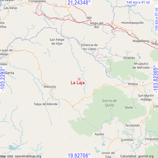
La Laja GPS coordinates[2]
20° 35' 12.084" North, 104° 31' 34.212" West
| Map corner | latitude | longitude |
|---|---|---|
| Upper-left | 21.24348°, | -105.2293° |
| Center: | 20.58669°, | -104.52617° |
| Lower-right: | 19.92706°, | -103.82305° |
| Map W x H: | 146.4×146.4 km | = 91×91mi |
| max Lat: | 32.7° ⇑30.3% North |
| La Laja: | 20.58669° |
| min Lat: | ⇓69.7% South 14.53588° |
| min Long | La Laja | max Long |
| -117.105° | -104.52617° | -86.73105° |
| W 9%⇐ | ⇒91% E |
Elevation
Elevation of La Laja is 1428 m = 4685 ft, and this is 174.3 m = 572 ft above average elevation for this country.
| Max E: |
3497 m = 11473 ft | 50% |
| La Laja | 1428 m 4685 ft | |
| Avg. | 1253.7 m = 4113 ft | |
Min E: |
-1 m = -3 ft | 50% |
See also: Mexico elevation on elevation.city.
Geographical zone
La Laja is located in North Torrid zone (between Equator and Tropic of Cancer). Distance of this Northern Tropic circle is 316.9 km =196.9 mi to North.| Distance of | km | miles | from La Laja |
|---|---|---|---|
| North Pole | 7718 | 4795.7 | to North |
| Arctic Circle | 5112.1 | 3176.5 | to North |
| Tropic Cancer | 316.9 | 196.9 | to North |
| Equator | 2289 | 1422.3 | to South |


Nearby cities:
15 places around La Laja: (largest is in red/bold)
• Amatlán de Cañas
27.6 km =17.1 mi,  27°
27°
• Atenguillo
19.3 km =12 mi,  169°
169°
• El Rosario
34.5 km =21.4 mi,  10°
10°
• El Salto
28.3 km =17.6 mi, 174°
• Guachinango
15.2 km =9.4 mi,  93°
93°
• Jayamitla
36.2 km =22.5 mi, 89°
• La Villita
36.8 km =22.9 mi, 89°
• Los Mezquites
36.5 km =22.7 mi,  357°
357°
• Los Volcanes
29.3 km =18.2 mi,  182°
182°
• Mascota
28.1 km =17.5 mi,  256°
256°
• Mixtlán
20.5 km =12.7 mi,  143°
143°
• Ocotes
38.5 km =23.9 mi,  241°
241°
• San Sebastián del Oeste
39.2 km =24.4 mi,  299°
299°
• Talpa de Allende
38.4 km =23.9 mi,  233°
233°
• Tepuzhuacán
32.3 km =20.1 mi,  1°
1°
Sources, notices
• [Note1] Compared only with cities in Mexico existing in our database
• [Src1] Map data: © OpenStreetMap contributors (CC-BY-SA)
• [Src2] Other city data from geonames.org with taken over terms of usage.
• [Src3] Geographical zone / Annual Mean Temperature by Robert A. Rohde @ Wikipedia
