Guachinango geodata
Guachinango (Jalisco) is a seat of a second-order administrative division; located in Mexico in America/Mexico_City (GMT-6) time zone. With population of 1,847 people, there are 4702 cities with bigger population in this country. Compared to other cities in Mexico, 69.5% of cities are located further ↓South; 90.8% of cities are located further →East and 51.3% of cities have lower elevation than Guachinango. Note1


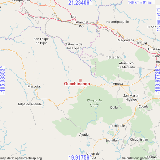
Guachinango GPS coordinates[2]
20° 34' 38.028" North, 104° 22' 49.44" West
| Map corner | latitude | longitude |
|---|---|---|
| Upper-left | 21.23406°, | -105.08353° |
| Center: | 20.57723°, | -104.3804° |
| Lower-right: | 19.91756°, | -103.67728° |
| Map W x H: | 146.4×146.4 km | = 91×91mi |
| max Lat: | 32.7° ⇑30.5% North |
| Guachinango: | 20.57723° |
| min Lat: | ⇓69.5% South 14.53588° |
| min Long | Guachinango | max Long |
| -117.105° | -104.3804° | -86.73105° |
| W 9.2%⇐ | ⇒90.8% E |
Elevation
Elevation of Guachinango is 1496 m = 4908 ft, and this is 242.3 m = 795 ft above average elevation for this country.
| Max E: |
3497 m = 11473 ft | 48.7% |
| Guachinango | 1496 m 4908 ft | |
| Avg. | 1253.7 m = 4113 ft | |
Min E: |
-1 m = -3 ft | 51.3% |
See also: Mexico elevation on elevation.city.
Geographical zone
Guachinango is located in North Torrid zone (between Equator and Tropic of Cancer). Distance of this Northern Tropic circle is 317.9 km =197.5 mi to North.| Distance of | km | miles | from Guachinango |
|---|---|---|---|
| North Pole | 7719.1 | 4796.4 | to North |
| Arctic Circle | 5113.2 | 3177.2 | to North |
| Tropic Cancer | 317.9 | 197.5 | to North |
| Equator | 2288 | 1421.7 | to South |


Nearby cities:
15 places around Guachinango: (largest is in red/bold)
• Amatlán de Cañas
25.7 km =16 mi,  354°
354°
• Ameca
35.1 km =21.8 mi,  95°
95°
• Atenguillo
21.5 km =13.4 mi,  213°
213°
• El Portezuelo
34.8 km =21.6 mi,  85°
85°
• El Salto
29.8 km =18.5 mi,  204°
204°
• Jayamitla
21.1 km =13.1 mi, 85°
• La Laja
15.2 km =9.4 mi,  273°
273°
• La Villita
21.7 km =13.5 mi, 87°
• Los Volcanes
32.7 km =20.3 mi, 210°
• Mixtlán
15.6 km =9.7 mi,  190°
190°
• Oconahua
29 km =18 mi,  50°
50°
• San Marcos
30.6 km =19 mi,  38°
38°
• San Nicolás
28.3 km =17.6 mi, 93°
• Soyatlán del Oro
32.3 km =20.1 mi,  161°
161°
• Texcalame
34.9 km =21.7 mi,  112°
112°
Sources, notices
• [Note1] Compared only with cities in Mexico existing in our database
• [Src1] Map data: © OpenStreetMap contributors (CC-BY-SA)
• [Src2] Other city data from geonames.org with taken over terms of usage.
• [Src3] Geographical zone / Annual Mean Temperature by Robert A. Rohde @ Wikipedia
