San Carlos del Jagüey geodata
San Carlos del Jagüey (Guanajuato) is a populated place; located in Mexico in America/Mexico_City (GMT-6) time zone. With population of 555 people, there are 15371 cities with bigger population in this country. Compared to other cities in Mexico, 75% of cities are located further ↓South; 78.5% of cities are located further →East and 62.1% of cities have lower elevation than San Carlos del Jagüey. Note1


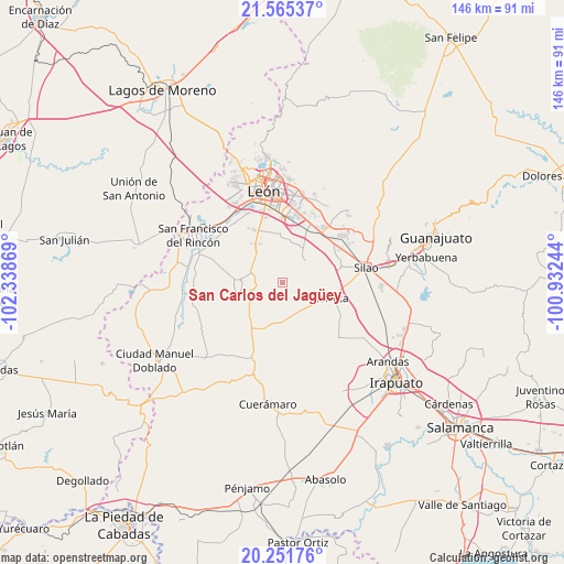
San Carlos del Jagüey GPS coordinates[2]
20° 54' 36" North, 101° 38' 8.016" West
| Map corner | latitude | longitude |
|---|---|---|
| Upper-left | 21.56537°, | -102.33869° |
| Center: | 20.91°, | -101.63556° |
| Lower-right: | 20.25176°, | -100.93244° |
| Map W x H: | 146.1×146.1 km | = 90.8×90.8mi |
| max Lat: | 32.7° ⇑25% North |
| San Carlos del Jagüey: | 20.91° |
| min Lat: | ⇓75% South 14.53588° |
| min Long | San Carlos del | max Long |
| -117.105° | -101.63556° | -86.73105° |
| W 21.5%⇐ | ⇒78.5% E |
Elevation
Elevation of San Carlos del Jagüey is 1762 m = 5781 ft, and this is 508.3 m = 1668 ft above average elevation for this country.
| Max E: |
3497 m = 11473 ft | 37.9% |
| San Carlos del Jagüey | 1762 m 5781 ft | |
| Avg. | 1253.7 m = 4113 ft | |
Min E: |
-1 m = -3 ft | 62.1% |
See also: Mexico elevation on elevation.city.
Geographical zone
San Carlos del Jagüey is located in North Torrid zone (between Equator and Tropic of Cancer). Distance of this Northern Tropic circle is 280.9 km =174.5 mi to North.| Distance of | km | miles | from San Carlos del Jagüey |
|---|---|---|---|
| North Pole | 7682.1 | 4773.4 | to North |
| Arctic Circle | 5076.2 | 3154.2 | to North |
| Tropic Cancer | 280.9 | 174.5 | to North |
| Equator | 2325 | 1444.7 | to South |


Nearby cities:
15 places around San Carlos del Jagüey: (largest is in red/bold)
• Barretos
3.3 km =2.1 mi,  346°
346°
• El Camaleón
2.5 km =1.6 mi,  173°
173°
• El Jaguey
0.6 km =0.4 mi,  13°
13°
• El Mármol
9.3 km =5.8 mi,  140°
140°
• Gavia de Rionda
8.7 km =5.4 mi, 166°
• La Arcina
4.1 km =2.5 mi,  32°
32°
• La Sardina
4.4 km =2.7 mi,  223°
223°
• Lourdes
6.5 km =4 mi, 138°
• Nuevo Lindero
5.4 km =3.4 mi,  357°
357°
• Plan Guanajuato (La Sandía)
6.5 km =4 mi,  281°
281°
• Plan Libertador
6.8 km =4.2 mi,  315°
315°
• Rancho Nuevo de la Luz
5.9 km =3.7 mi, 349°
• San Cristóbal
10.1 km =6.3 mi, 318°
• San Gonzalo
7.2 km =4.5 mi,  110°
110°
• Silva
9 km =5.6 mi,  100°
100°
Sources, notices
• [Note1] Compared only with cities in Mexico existing in our database
• [Src1] Map data: © OpenStreetMap contributors (CC-BY-SA)
• [Src2] Other city data from geonames.org with taken over terms of usage.
• [Src3] Geographical zone / Annual Mean Temperature by Robert A. Rohde @ Wikipedia
