Zatzio (Tzatzio) geodata
Zatzio (Tzatzio) (Michoacán) is a populated place; located in Mexico in America/Mexico_City (GMT-6) time zone. With population of 946 people, there are 9202 cities with bigger population in this country. Compared to other cities in Mexico, 60.6% of cities are located further ↑North; 78.2% of cities are located further →East and 78.9% of cities have lower elevation than Zatzio (Tzatzio). Note1


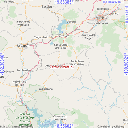
Zatzio (Tzatzio) GPS coordinates[2]
19° 13' 16.608" North, 101° 36' 11.988" West
| Map corner | latitude | longitude |
|---|---|---|
| Upper-left | 19.88385°, | -102.30646° |
| Center: | 19.22128°, | -101.60333° |
| Lower-right: | 18.55602°, | -100.90021° |
| Map W x H: | 147.6×147.6 km | = 91.7×91.7mi |
| max Lat: | 32.7° ⇑60.6% North |
| Zatzio (Tzatzio): | 19.22128° |
| min Lat: | ⇓39.4% South 14.53588° |
| min Long | Zatzio (Tzatzio | max Long |
| -117.105° | -101.60333° | -86.73105° |
| W 21.8%⇐ | ⇒78.2% E |
Elevation
Elevation of Zatzio (Tzatzio) is 2111 m = 6926 ft, and this is 857.3 m = 2813 ft above average elevation for this country.
| Max E: |
3497 m = 11473 ft | 21.1% |
| Zatzio (Tzatzio) | 2111 m 6926 ft | |
| Avg. | 1253.7 m = 4113 ft | |
Min E: |
-1 m = -3 ft | 78.9% |
See also: Mexico elevation on elevation.city.
Geographical zone
Zatzio (Tzatzio) is located in North Torrid zone (between Equator and Tropic of Cancer). Distance of this Northern Tropic circle is 468.7 km =291.2 mi to North.| Distance of | km | miles | from Zatzio (Tzatzio) |
|---|---|---|---|
| North Pole | 7869.9 | 4890.1 | to North |
| Arctic Circle | 5264 | 3270.9 | to North |
| Tropic Cancer | 468.7 | 291.2 | to North |
| Equator | 2137.2 | 1328 | to South |


Nearby cities:
15 places around Zatzio (Tzatzio): (largest is in red/bold)
• Ario de Rosales
11 km =6.8 mi,  262°
262°
• Camémbaro
12.3 km =7.6 mi,  334°
334°
• Doctor Miguel Silva Macías
14.4 km =8.9 mi,  244°
244°
• El Chupadero
4.8 km =3 mi,  217°
217°
• El Tepamal
2.5 km =1.6 mi, 328°
• El Terrero
8.4 km =5.2 mi,  83°
83°
• Los Hacheros
9.6 km =6 mi,  158°
158°
• Los Tumines
14.6 km =9.1 mi, 240°
• Pablo Cuin
6.1 km =3.8 mi,  269°
269°
• Pinal Grande
13.7 km =8.5 mi,  167°
167°
• San José Grande
4.5 km =2.8 mi,  87°
87°
• San Rafael Tecario
10.3 km =6.4 mi,  96°
96°
• Santas Marías
9.1 km =5.7 mi,  64°
64°
• Serrano
11.8 km =7.3 mi, 58°
• Tecario
6.3 km =3.9 mi, 78°
Sources, notices
• [Note1] Compared only with cities in Mexico existing in our database
• [Src1] Map data: © OpenStreetMap contributors (CC-BY-SA)
• [Src2] Other city data from geonames.org with taken over terms of usage.
• [Src3] Geographical zone / Annual Mean Temperature by Robert A. Rohde @ Wikipedia
