La Huacana geodata
La Huacana (Michoacán) is a seat of a second-order administrative division; located in Mexico in America/Mexico_City (GMT-6) time zone. With population of 9,395 people, there are 1016 cities with bigger population in this country. Compared to other cities in Mexico, 65.5% of cities are located further ↑North; 79.8% of cities are located further →East and 68.7% of cities have higher elevation than La Huacana. Note1


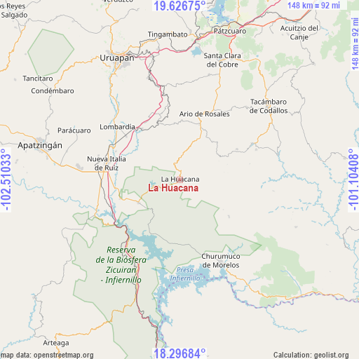
La Huacana GPS coordinates[2]
18° 57' 47.232" North, 101° 48' 25.92" West
| Map corner | latitude | longitude |
|---|---|---|
| Upper-left | 19.62675°, | -102.51033° |
| Center: | 18.96312°, | -101.8072° |
| Lower-right: | 18.29684°, | -101.10408° |
| Map W x H: | 147.9×147.9 km | = 91.9×91.9mi |
| max Lat: | 32.7° ⇑65.5% North |
| La Huacana: | 18.96312° |
| min Lat: | ⇓34.5% South 14.53588° |
| min Long | La Huacana | max Long |
| -117.105° | -101.8072° | -86.73105° |
| W 20.2%⇐ | ⇒79.8% E |
Elevation
Elevation of La Huacana is 489 m = 1604 ft, and this is 764.7 m = 2509 ft below average elevation for this country.
| Max E: |
3497 m = 11473 ft | 68.7% |
| Avg. | 1253.7 m = 4113 ft | |
| La Huacana | 489 m = 1604 ft | |
Min E: |
-1 m = -3 ft | 31.3% |
See also: Mexico elevation on elevation.city.
Geographical zone
La Huacana is located in North Torrid zone (between Equator and Tropic of Cancer). Distance of this Northern Tropic circle is 497.4 km =309.1 mi to North.| Distance of | km | miles | from La Huacana |
|---|---|---|---|
| North Pole | 7898.6 | 4908 | to North |
| Arctic Circle | 5292.7 | 3288.7 | to North |
| Tropic Cancer | 497.4 | 309.1 | to North |
| Equator | 2108.5 | 1310.2 | to South |


Nearby cities:
15 places around La Huacana: (largest is in red/bold)
• Doctor Miguel Silva Macías
24 km =14.9 mi,  20°
20°
• El Cahulote de Santa Ana
26.8 km =16.7 mi,  61°
61°
• El Chauz
25.7 km =16 mi,  252°
252°
• Ichamio
2.2 km =1.4 mi,  235°
235°
• La Ibérica (La Gotera)
25.2 km =15.7 mi,  332°
332°
• Las Puentes
18.4 km =11.4 mi, 61°
• Los Otates
23.1 km =14.4 mi,  354°
354°
• Los Tumines
23.2 km =14.4 mi, 22°
• Mata de Plátano
9.9 km =6.2 mi,  92°
92°
• Nuevo Urecho
23.5 km =14.6 mi,  344°
344°
• Poturo
25.5 km =15.8 mi,  126°
126°
• Santa Casilda
26.1 km =16.2 mi,  323°
323°
• Urapa
20.8 km =12.9 mi,  40°
40°
• Villa Eréndira
25.1 km =15.6 mi, 339°
• Zicuirán
19.4 km =12.1 mi, 240°
Sources, notices
• [Note1] Compared only with cities in Mexico existing in our database
• [Src1] Map data: © OpenStreetMap contributors (CC-BY-SA)
• [Src2] Other city data from geonames.org with taken over terms of usage.
• [Src3] Geographical zone / Annual Mean Temperature by Robert A. Rohde @ Wikipedia
