Las Puentes geodata
Las Puentes (Michoacán) is a populated place; located in Mexico in America/Mexico_City (GMT-6) time zone. With population of 563 people, there are 15167 cities with bigger population in this country. Compared to other cities in Mexico, 64% of cities are located further ↑North; 78.7% of cities are located further →East and 64.5% of cities have lower elevation than Las Puentes. Note1


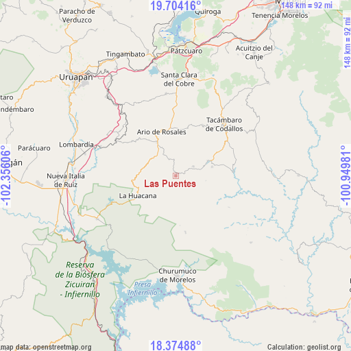
Las Puentes GPS coordinates[2]
19° 2' 27.06" North, 101° 39' 10.548" West
| Map corner | latitude | longitude |
|---|---|---|
| Upper-left | 19.70416°, | -102.35606° |
| Center: | 19.04085°, | -101.65293° |
| Lower-right: | 18.37488°, | -100.94981° |
| Map W x H: | 147.8×147.8 km | = 91.8×91.8mi |
| max Lat: | 32.7° ⇑64% North |
| Las Puentes: | 19.04085° |
| min Lat: | ⇓36% South 14.53588° |
| min Long | Las Puentes | max Long |
| -117.105° | -101.65293° | -86.73105° |
| W 21.3%⇐ | ⇒78.7% E |
Elevation
Elevation of Las Puentes is 1814 m = 5951 ft, and this is 560.3 m = 1838 ft above average elevation for this country.
| Max E: |
3497 m = 11473 ft | 35.5% |
| Las Puentes | 1814 m 5951 ft | |
| Avg. | 1253.7 m = 4113 ft | |
Min E: |
-1 m = -3 ft | 64.5% |
See also: Mexico elevation on elevation.city.
Geographical zone
Las Puentes is located in North Torrid zone (between Equator and Tropic of Cancer). Distance of this Northern Tropic circle is 488.8 km =303.7 mi to North.| Distance of | km | miles | from Las Puentes |
|---|---|---|---|
| North Pole | 7889.9 | 4902.6 | to North |
| Arctic Circle | 5284 | 3283.3 | to North |
| Tropic Cancer | 488.8 | 303.7 | to North |
| Equator | 2117.1 | 1315.5 | to South |


Nearby cities:
15 places around Las Puentes: (largest is in red/bold)
• Ario de Rosales
19.6 km =12.2 mi,  342°
342°
• Doctor Miguel Silva Macías
15.8 km =9.8 mi,  330°
330°
• El Cahulote de Santa Ana
8.4 km =5.2 mi,  62°
62°
• El Chupadero
16.4 km =10.2 mi,  8°
8°
• La Ermita (Nueva Jerusalén)
15.8 km =9.8 mi,  76°
76°
• La Huacana
18.4 km =11.4 mi,  241°
241°
• La Huerta
16.1 km =10 mi,  66°
66°
• Los Hacheros
14.2 km =8.8 mi,  38°
38°
• Los Tumines
14.9 km =9.3 mi, 329°
• Mata de Plátano
11.1 km =6.9 mi,  214°
214°
• Petembo
19 km =11.8 mi, 61°
• Pinal Grande
10.6 km =6.6 mi,  50°
50°
• Puruarán
15 km =9.3 mi, 65°
• Tavera
10.1 km =6.3 mi, 77°
• Urapa
7.5 km =4.7 mi, 340°
Sources, notices
• [Note1] Compared only with cities in Mexico existing in our database
• [Src1] Map data: © OpenStreetMap contributors (CC-BY-SA)
• [Src2] Other city data from geonames.org with taken over terms of usage.
• [Src3] Geographical zone / Annual Mean Temperature by Robert A. Rohde @ Wikipedia
