Pantoja geodata
Pantoja (State of Mexico) is a populated place; located in Mexico in America/Mexico_City (GMT-6) time zone. With population of 854 people, there are 10250 cities with bigger population in this country. Compared to other cities in Mexico, 67.6% of cities are located further ↑North; 64.2% of cities are located further →East and 60.4% of cities have lower elevation than Pantoja. Note1


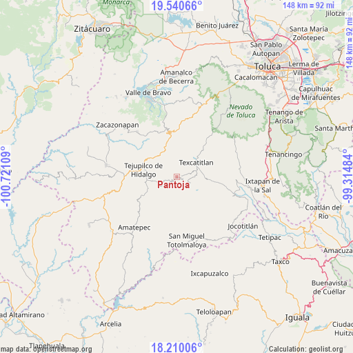
Pantoja GPS coordinates[2]
18° 52' 36.048" North, 100° 1' 4.656" West
| Map corner | latitude | longitude |
|---|---|---|
| Upper-left | 19.54066°, | -100.72109° |
| Center: | 18.87668°, | -100.01796° |
| Lower-right: | 18.21006°, | -99.31484° |
| Map W x H: | 147.9×148 km | = 91.9×92mi |
| max Lat: | 32.7° ⇑67.6% North |
| Pantoja: | 18.87668° |
| min Lat: | ⇓32.4% South 14.53588° |
| min Long | Pantoja | max Long |
| -117.105° | -100.01796° | -86.73105° |
| W 35.8%⇐ | ⇒64.2% E |
Elevation
Elevation of Pantoja is 1732 m = 5682 ft, and this is 478.3 m = 1569 ft above average elevation for this country.
| Max E: |
3497 m = 11473 ft | 39.6% |
| Pantoja | 1732 m 5682 ft | |
| Avg. | 1253.7 m = 4113 ft | |
Min E: |
-1 m = -3 ft | 60.4% |
See also: Mexico elevation on elevation.city.
Geographical zone
Pantoja is located in North Torrid zone (between Equator and Tropic of Cancer). Distance of this Northern Tropic circle is 507 km =315 mi to North.| Distance of | km | miles | from Pantoja |
|---|---|---|---|
| North Pole | 7908.2 | 4913.9 | to North |
| Arctic Circle | 5302.3 | 3294.7 | to North |
| Tropic Cancer | 507 | 315 | to North |
| Equator | 2098.9 | 1304.2 | to South |


Nearby cities:
15 places around Pantoja: (largest is in red/bold)
• Acatitlán
8.8 km =5.5 mi,  54°
54°
• Capula
6.1 km =3.8 mi,  96°
96°
• Diego Sánchez
8.8 km =5.5 mi,  127°
127°
• El Chapaneal
10.4 km =6.5 mi,  40°
40°
• Hueyatenco
5.4 km =3.4 mi,  75°
75°
• La Labor de Zaragoza
8.5 km =5.3 mi,  266°
266°
• Llano Grande
10.1 km =6.3 mi,  241°
241°
• San Agustín
11 km =6.8 mi, 48°
• San Andrés Ocotepec
4.3 km =2.7 mi,  314°
314°
• San Andrés Tepetitlán
10.6 km =6.6 mi, 76°
• San Francisco
10 km =6.2 mi,  69°
69°
• San Isidro Xochitla
9.3 km =5.8 mi,  180°
180°
• Santa Cruz
6 km =3.7 mi,  142°
142°
• Sultepec
5.8 km =3.6 mi,  110°
110°
• Texcaltitlán
10.3 km =6.4 mi, 54°
Sources, notices
• [Note1] Compared only with cities in Mexico existing in our database
• [Src1] Map data: © OpenStreetMap contributors (CC-BY-SA)
• [Src2] Other city data from geonames.org with taken over terms of usage.
• [Src3] Geographical zone / Annual Mean Temperature by Robert A. Rohde @ Wikipedia
