San Andrés Ocotepec geodata
San Andrés Ocotepec (State of Mexico) is a populated place; located in Mexico in America/Mexico_City (GMT-6) time zone. With population of 1,708 people, there are 5088 cities with bigger population in this country. Compared to other cities in Mexico, 66.9% of cities are located further ↑North; 64.5% of cities are located further →East and 54.9% of cities have lower elevation than San Andrés Ocotepec. Note1


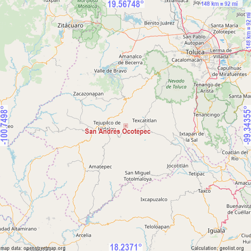
San Andrés Ocotepec GPS coordinates[2]
18° 54' 12.996" North, 100° 2' 48.012" West
| Map corner | latitude | longitude |
|---|---|---|
| Upper-left | 19.56748°, | -100.7498° |
| Center: | 18.90361°, | -100.04667° |
| Lower-right: | 18.2371°, | -99.34355° |
| Map W x H: | 147.9×147.9 km | = 91.9×91.9mi |
| max Lat: | 32.7° ⇑66.9% North |
| San Andrés Ocotepec: | 18.90361° |
| min Lat: | ⇓33.1% South 14.53588° |
| min Long | San Andrés Oco | max Long |
| -117.105° | -100.04667° | -86.73105° |
| W 35.5%⇐ | ⇒64.5% E |
Elevation
Elevation of San Andrés Ocotepec is 1586 m = 5203 ft, and this is 332.3 m = 1090 ft above average elevation for this country.
| Max E: |
3497 m = 11473 ft | 45.1% |
| San Andrés Ocotepec | 1586 m 5203 ft | |
| Avg. | 1253.7 m = 4113 ft | |
Min E: |
-1 m = -3 ft | 54.9% |
See also: Mexico elevation on elevation.city.
Geographical zone
San Andrés Ocotepec is located in North Torrid zone (between Equator and Tropic of Cancer). Distance of this Northern Tropic circle is 504 km =313.2 mi to North.| Distance of | km | miles | from San Andrés Ocotepec |
|---|---|---|---|
| North Pole | 7905.2 | 4912.1 | to North |
| Arctic Circle | 5299.3 | 3292.8 | to North |
| Tropic Cancer | 504 | 313.2 | to North |
| Equator | 2101.9 | 1306.1 | to South |


Nearby cities:
15 places around San Andrés Ocotepec: (largest is in red/bold)
• Acatitlán
10.4 km =6.5 mi,  78°
78°
• Capula
9.8 km =6.1 mi,  112°
112°
• El Chapaneal
11 km =6.8 mi,  63°
63°
• Hueyatenco
8.5 km =5.3 mi,  101°
101°
• La Labor de Zaragoza
6.5 km =4 mi,  236°
236°
• Llano Grande
9.8 km =6.1 mi,  216°
216°
• Pantoja
4.3 km =2.7 mi,  134°
134°
• Rincón de Aguirre
9.5 km =5.9 mi,  267°
267°
• Rincón del Carmen
7.8 km =4.8 mi, 268°
• San Diego Cuentla (Llano Grande)
7.3 km =4.5 mi,  341°
341°
• San Gabriel Cuentla
7.3 km =4.5 mi,  352°
352°
• Santa Cruz
10.3 km =6.4 mi,  139°
139°
• Sultepec
9.9 km =6.2 mi,  120°
120°
• Tejupilco de Hidalgo
11.2 km =7 mi, 270°
• Tenería
9.1 km =5.7 mi,  327°
327°
Sources, notices
• [Note1] Compared only with cities in Mexico existing in our database
• [Src1] Map data: © OpenStreetMap contributors (CC-BY-SA)
• [Src2] Other city data from geonames.org with taken over terms of usage.
• [Src3] Geographical zone / Annual Mean Temperature by Robert A. Rohde @ Wikipedia
