El Gallo geodata
El Gallo (Querétaro) is a populated place; located in Mexico in America/Mexico_City (GMT-6) time zone. With population of 1,688 people, there are 5145 cities with bigger population in this country. Compared to other cities in Mexico, 71.3% of cities are located further ↓South; 64.5% of cities are located further →East and 74.5% of cities have lower elevation than El Gallo. Note1


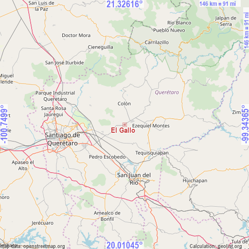
El Gallo GPS coordinates[2]
20° 40' 11.028" North, 100° 2' 48.372" West
| Map corner | latitude | longitude |
|---|---|---|
| Upper-left | 21.32616°, | -100.7499° |
| Center: | 20.66973°, | -100.04677° |
| Lower-right: | 20.01045°, | -99.34365° |
| Map W x H: | 146.3×146.3 km | = 90.9×90.9mi |
| max Lat: | 32.7° ⇑28.7% North |
| El Gallo: | 20.66973° |
| min Lat: | ⇓71.3% South 14.53588° |
| min Long | El Gallo | max Long |
| -117.105° | -100.04677° | -86.73105° |
| W 35.5%⇐ | ⇒64.5% E |
Elevation
Elevation of El Gallo is 2022 m = 6634 ft, and this is 768.3 m = 2521 ft above average elevation for this country.
| Max E: |
3497 m = 11473 ft | 25.5% |
| El Gallo | 2022 m 6634 ft | |
| Avg. | 1253.7 m = 4113 ft | |
Min E: |
-1 m = -3 ft | 74.5% |
See also: Mexico elevation on elevation.city.
Geographical zone
El Gallo is located in North Torrid zone (between Equator and Tropic of Cancer). Distance of this Northern Tropic circle is 307.7 km =191.2 mi to North.| Distance of | km | miles | from El Gallo |
|---|---|---|---|
| North Pole | 7708.8 | 4790 | to North |
| Arctic Circle | 5102.9 | 3170.8 | to North |
| Tropic Cancer | 307.7 | 191.2 | to North |
| Equator | 2298.3 | 1428.1 | to South |


Nearby cities:
15 places around El Gallo: (largest is in red/bold)
• Ajuchitlán
5 km =3.1 mi,  33°
33°
• El Blanco
8.7 km =5.4 mi,  221°
221°
• El Nuevo Rumbo
8.4 km =5.2 mi,  9°
9°
• El Tejocote
5.7 km =3.5 mi,  167°
167°
• Esperanza
7.2 km =4.5 mi,  248°
248°
• Las Cenizas
7.6 km =4.7 mi,  201°
201°
• Los Benitos
9.6 km =6 mi,  79°
79°
• Los Quiotes (San José los Quiotes)
9.1 km =5.7 mi,  357°
357°
• Palmas
4.9 km =3 mi,  302°
302°
• Purísima de Cubos (La Purísima)
10.7 km =6.6 mi, 223°
• San José de la Laja
9.4 km =5.8 mi,  127°
127°
• San Martín
9.5 km =5.9 mi,  51°
51°
• Santa Rosa Finca
8.4 km =5.2 mi,  90°
90°
• Santa Rosa de Lima
7.1 km =4.4 mi, 93°
• Urecho
3.3 km =2.1 mi,  238°
238°
Sources, notices
• [Note1] Compared only with cities in Mexico existing in our database
• [Src1] Map data: © OpenStreetMap contributors (CC-BY-SA)
• [Src2] Other city data from geonames.org with taken over terms of usage.
• [Src3] Geographical zone / Annual Mean Temperature by Robert A. Rohde @ Wikipedia
