Palmas geodata
Palmas (Querétaro) is a populated place; located in Mexico in America/Mexico_City (GMT-6) time zone. With population of 587 people, there are 14622 cities with bigger population in this country. Compared to other cities in Mexico, 71.5% of cities are located further ↓South; 65% of cities are located further →East and 78.4% of cities have lower elevation than Palmas. Note1


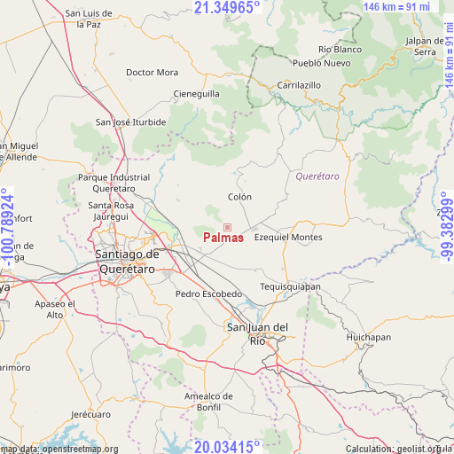
Palmas GPS coordinates[2]
20° 41' 35.988" North, 100° 5' 9.996" West
| Map corner | latitude | longitude |
|---|---|---|
| Upper-left | 21.34965°, | -100.78924° |
| Center: | 20.69333°, | -100.08611° |
| Lower-right: | 20.03415°, | -99.38299° |
| Map W x H: | 146.3×146.3 km | = 90.9×90.9mi |
| max Lat: | 32.7° ⇑28.5% North |
| Palmas: | 20.69333° |
| min Lat: | ⇓71.5% South 14.53588° |
| min Long | Palmas | max Long |
| -117.105° | -100.08611° | -86.73105° |
| W 35%⇐ | ⇒65% E |
Elevation
Elevation of Palmas is 2097 m = 6880 ft, and this is 843.3 m = 2767 ft above average elevation for this country.
| Max E: |
3497 m = 11473 ft | 21.6% |
| Palmas | 2097 m 6880 ft | |
| Avg. | 1253.7 m = 4113 ft | |
Min E: |
-1 m = -3 ft | 78.4% |
See also: Mexico elevation on elevation.city.
Geographical zone
Palmas is located in North Torrid zone (between Equator and Tropic of Cancer). Distance of this Northern Tropic circle is 305 km =189.5 mi to North.| Distance of | km | miles | from Palmas |
|---|---|---|---|
| North Pole | 7706.2 | 4788.4 | to North |
| Arctic Circle | 5100.3 | 3169.2 | to North |
| Tropic Cancer | 305 | 189.5 | to North |
| Equator | 2300.9 | 1429.7 | to South |


Nearby cities:
15 places around Palmas: (largest is in red/bold)
• Ajuchitlán
7 km =4.3 mi,  77°
77°
• Colón
10.6 km =6.6 mi,  19°
19°
• El Blanco
9.3 km =5.8 mi,  190°
190°
• El Gallo
4.9 km =3 mi,  122°
122°
• El Nuevo Rumbo
7.9 km =4.9 mi,  44°
44°
• El Tejocote
9.8 km =6.1 mi,  146°
146°
• Esperanza
5.9 km =3.7 mi,  206°
206°
• Galeras
11.2 km =7 mi,  221°
221°
• Las Cenizas
9.8 km =6.1 mi,  172°
172°
• Los Quiotes (San José los Quiotes)
7.5 km =4.7 mi,  29°
29°
• Nogales
6.2 km =3.9 mi,  275°
275°
• Puerta de Enmedio
9.8 km =6.1 mi,  322°
322°
• Purísima de Cubos (La Purísima)
10.9 km =6.8 mi,  197°
197°
• Urecho
4.6 km =2.9 mi,  164°
164°
• Vista Hermosa
11.3 km =7 mi,  307°
307°
Sources, notices
• [Note1] Compared only with cities in Mexico existing in our database
• [Src1] Map data: © OpenStreetMap contributors (CC-BY-SA)
• [Src2] Other city data from geonames.org with taken over terms of usage.
• [Src3] Geographical zone / Annual Mean Temperature by Robert A. Rohde @ Wikipedia
