Ajuchitlán geodata
Ajuchitlán (Querétaro) is a populated place; located in Mexico in America/Mexico_City (GMT-6) time zone. With population of 5,483 people, there are 1698 cities with bigger population in this country. Compared to other cities in Mexico, 71.8% of cities are located further ↓South; 64.2% of cities are located further →East and 72.2% of cities have lower elevation than Ajuchitlán. Note1


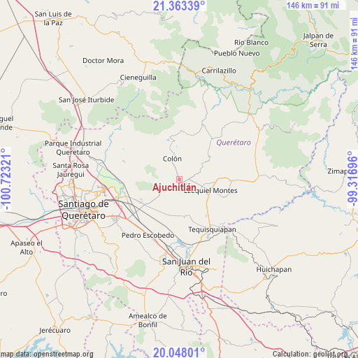
Ajuchitlán GPS coordinates[2]
20° 42' 25.668" North, 100° 1' 12.288" West
| Map corner | latitude | longitude |
|---|---|---|
| Upper-left | 21.36339°, | -100.72321° |
| Center: | 20.70713°, | -100.02008° |
| Lower-right: | 20.04801°, | -99.31696° |
| Map W x H: | 146.3×146.3 km | = 90.9×90.9mi |
| max Lat: | 32.7° ⇑28.2% North |
| Ajuchitlán: | 20.70713° |
| min Lat: | ⇓71.8% South 14.53588° |
| min Long | Ajuchitlán | max Long |
| -117.105° | -100.02008° | -86.73105° |
| W 35.8%⇐ | ⇒64.2% E |
Elevation
Elevation of Ajuchitlán is 1970 m = 6463 ft, and this is 716.3 m = 2350 ft above average elevation for this country.
| Max E: |
3497 m = 11473 ft | 27.8% |
| Ajuchitlán | 1970 m 6463 ft | |
| Avg. | 1253.7 m = 4113 ft | |
Min E: |
-1 m = -3 ft | 72.2% |
See also: Mexico elevation on elevation.city.
Geographical zone
Ajuchitlán is located in North Torrid zone (between Equator and Tropic of Cancer). Distance of this Northern Tropic circle is 303.5 km =188.6 mi to North.| Distance of | km | miles | from Ajuchitlán |
|---|---|---|---|
| North Pole | 7704.6 | 4787.4 | to North |
| Arctic Circle | 5098.8 | 3168.2 | to North |
| Tropic Cancer | 303.5 | 188.6 | to North |
| Equator | 2302.4 | 1430.6 | to South |


Nearby cities:
15 places around Ajuchitlán: (largest is in red/bold)
• Bernal
9 km =5.6 mi,  65°
65°
• Colón
9.1 km =5.7 mi,  338°
338°
• El Gallo
5 km =3.1 mi,  213°
213°
• El Nuevo Rumbo
4.3 km =2.7 mi, 342°
• El Tejocote
9.8 km =6.1 mi,  188°
188°
• Los Benitos
7.1 km =4.4 mi,  110°
110°
• Los Quiotes (San José los Quiotes)
5.9 km =3.7 mi,  327°
327°
• Palmas
7 km =4.3 mi,  257°
257°
• San Antonio de la Cal
10.8 km =6.7 mi,  52°
52°
• San José de la Laja
10.9 km =6.8 mi,  154°
154°
• San José del Jagüey
10.5 km =6.5 mi, 71°
• San Martín
5 km =3.1 mi, 69°
• Santa Rosa Finca
7 km =4.3 mi,  127°
127°
• Santa Rosa de Lima
6.3 km =3.9 mi,  136°
136°
• Urecho
8.2 km =5.1 mi,  223°
223°
Sources, notices
• [Note1] Compared only with cities in Mexico existing in our database
• [Src1] Map data: © OpenStreetMap contributors (CC-BY-SA)
• [Src2] Other city data from geonames.org with taken over terms of usage.
• [Src3] Geographical zone / Annual Mean Temperature by Robert A. Rohde @ Wikipedia
