Las Placetas geodata
Las Placetas (Veracruz) is a populated place; located in Mexico in America/Mexico_City (GMT-6) time zone. With population of 599 people, there are 14365 cities with bigger population in this country. Compared to other cities in Mexico, 76.9% of cities are located further ↓South; 63.4% of cities are located further ←West and 77.4% of cities have higher elevation than Las Placetas. Note1


Las Placetas GPS coordinates[2]
21° 1' 57.72" North, 98° 0' 49.608" West
| Map corner | latitude | longitude |
|---|---|---|
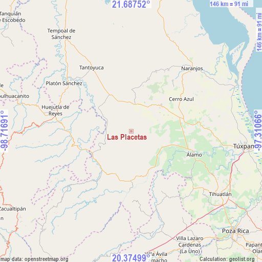
| Upper-left | 21.68752°, | -98.71691° |
| Center: | 21.0327°, | -98.01378° |
| Lower-right: | 20.37499°, | -97.31066° |
| Map W x H: | 145.9×145.9 km | = 90.7×90.7mi |
| max Lat: | 32.7° ⇑23.1% North |
| Las Placetas: | 21.0327° |
| min Lat: | ⇓76.9% South 14.53588° |
| min Long | Las Placetas | max Long |
| -117.105° | -98.01378° | -86.73105° |
| W 63.4%⇐ | ⇒36.6% E |
Elevation
Elevation of Las Placetas is 144 m = 472 ft, and this is 1109.7 m = 3641 ft below average elevation for this country.
| Max E: |
3497 m = 11473 ft | 77.4% |
| Avg. | 1253.7 m = 4113 ft | |
| Las Placetas | 144 m = 472 ft | |
Min E: |
-1 m = -3 ft | 22.6% |
See also: Mexico elevation on elevation.city.
Geographical zone
Las Placetas is located in North Torrid zone (between Equator and Tropic of Cancer). Distance of this Northern Tropic circle is 267.3 km =166.1 mi to North.| Distance of | km | miles | from Las Placetas |
|---|---|---|---|
| North Pole | 7668.4 | 4764.9 | to North |
| Arctic Circle | 5062.6 | 3145.8 | to North |
| Tropic Cancer | 267.3 | 166.1 | to North |
| Equator | 2338.6 | 1453.1 | to South |


Nearby cities:
15 places around Las Placetas: (largest is in red/bold)
• Ahuateno
14.6 km =9.1 mi,  256°
256°
• Ayacaxtle
7.6 km =4.7 mi,  164°
164°
• Chicontepec
17.8 km =11.1 mi,  247°
247°
• El Humo
17.6 km =10.9 mi,  25°
25°
• El Mirador
7.6 km =4.7 mi,  107°
107°
• Francia Nueva
11.3 km =7 mi, 34°
• Huizache Achichipic
15.3 km =9.5 mi,  238°
238°
• Ixcacuatitla
13.9 km =8.6 mi,  184°
184°
• La Pagua
6.8 km =4.2 mi, 158°
• Las Puentes
2.3 km =1.4 mi,  38°
38°
• Pastoría
14.5 km =9 mi,  295°
295°
• Reyixtla
18 km =11.2 mi,  193°
193°
• Tecomate
7.2 km =4.5 mi,  196°
196°
• Tierra Blanca
17.1 km =10.6 mi, 34°
• Tlacolula
8.6 km =5.3 mi, 40°
Sources, notices
• [Note1] Compared only with cities in Mexico existing in our database
• [Src1] Map data: © OpenStreetMap contributors (CC-BY-SA)
• [Src2] Other city data from geonames.org with taken over terms of usage.
• [Src3] Geographical zone / Annual Mean Temperature by Robert A. Rohde @ Wikipedia
