Tecomate geodata
Tecomate (Veracruz) is a populated place; located in Mexico in America/Mexico_City (GMT-6) time zone. With population of 547 people, there are 15556 cities with bigger population in this country. Compared to other cities in Mexico, 76% of cities are located further ↓South; 63.2% of cities are located further ←West and 76.3% of cities have higher elevation than Tecomate. Note1


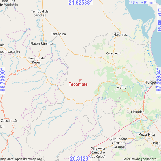
Tecomate GPS coordinates[2]
20° 58' 14.808" North, 98° 1' 58.656" West
| Map corner | latitude | longitude |
|---|---|---|
| Upper-left | 21.62588°, | -98.73609° |
| Center: | 20.97078°, | -98.03296° |
| Lower-right: | 20.3128°, | -97.32984° |
| Map W x H: | 146×146 km | = 90.7×90.7mi |
| max Lat: | 32.7° ⇑24% North |
| Tecomate: | 20.97078° |
| min Lat: | ⇓76% South 14.53588° |
| min Long | Tecomate | max Long |
| -117.105° | -98.03296° | -86.73105° |
| W 63.2%⇐ | ⇒36.8% E |
Elevation
Elevation of Tecomate is 177 m = 581 ft, and this is 1076.7 m = 3532 ft below average elevation for this country.
| Max E: |
3497 m = 11473 ft | 76.3% |
| Avg. | 1253.7 m = 4113 ft | |
| Tecomate | 177 m = 581 ft | |
Min E: |
-1 m = -3 ft | 23.7% |
See also: Mexico elevation on elevation.city.
Geographical zone
Tecomate is located in North Torrid zone (between Equator and Tropic of Cancer). Distance of this Northern Tropic circle is 274.2 km =170.4 mi to North.| Distance of | km | miles | from Tecomate |
|---|---|---|---|
| North Pole | 7675.3 | 4769.2 | to North |
| Arctic Circle | 5069.4 | 3150 | to North |
| Tropic Cancer | 274.2 | 170.4 | to North |
| Equator | 2331.7 | 1448.9 | to South |


Nearby cities:
15 places around Tecomate: (largest is in red/bold)
• Ahuateno
12.7 km =7.9 mi,  286°
286°
• Alahualtitla
14.8 km =9.2 mi,  250°
250°
• Ayacaxtle
4 km =2.5 mi,  96°
96°
• Chicontepec
14.5 km =9 mi,  270°
270°
• El Limón
14.9 km =9.3 mi,  186°
186°
• El Mirador
10.3 km =6.4 mi,  63°
63°
• Huizache Achichipic
11.1 km =6.9 mi,  264°
264°
• Ixcacuatitla
7 km =4.3 mi,  171°
171°
• La Pagua
4.5 km =2.8 mi,  83°
83°
• Las Placetas
7.2 km =4.5 mi,  16°
16°
• Las Puentes
9.3 km =5.8 mi, 21°
• Pemuxtitla
14.2 km =8.8 mi,  241°
241°
• Reyixtla
10.9 km =6.8 mi, 192°
• Tlacolula
15.5 km =9.6 mi,  29°
29°
• Xochimilco
12.6 km =7.8 mi,  197°
197°
Sources, notices
• [Note1] Compared only with cities in Mexico existing in our database
• [Src1] Map data: © OpenStreetMap contributors (CC-BY-SA)
• [Src2] Other city data from geonames.org with taken over terms of usage.
• [Src3] Geographical zone / Annual Mean Temperature by Robert A. Rohde @ Wikipedia
