El Mirador geodata
El Mirador (Veracruz) is a populated place; located in Mexico in America/Mexico_City (GMT-6) time zone. With population of 1,353 people, there are 6427 cities with bigger population in this country. Compared to other cities in Mexico, 76.6% of cities are located further ↓South; 64.3% of cities are located further ←West and 76.7% of cities have higher elevation than El Mirador. Note1


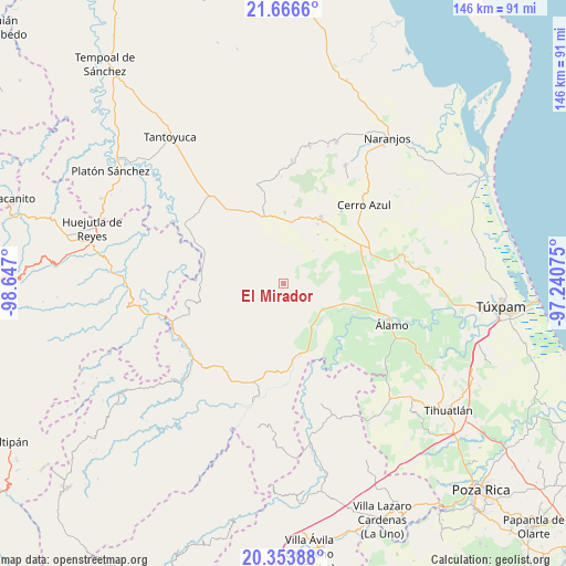
El Mirador GPS coordinates[2]
21° 0' 42.048" North, 97° 56' 37.932" West
| Map corner | latitude | longitude |
|---|---|---|
| Upper-left | 21.6666°, | -98.647° |
| Center: | 21.01168°, | -97.94387° |
| Lower-right: | 20.35388°, | -97.24075° |
| Map W x H: | 146×146 km | = 90.7×90.7mi |
| max Lat: | 32.7° ⇑23.4% North |
| El Mirador: | 21.01168° |
| min Lat: | ⇓76.6% South 14.53588° |
| min Long | El Mirador | max Long |
| -117.105° | -97.94387° | -86.73105° |
| W 64.3%⇐ | ⇒35.7% E |
Elevation
Elevation of El Mirador is 162 m = 531 ft, and this is 1091.7 m = 3582 ft below average elevation for this country.
| Max E: |
3497 m = 11473 ft | 76.7% |
| Avg. | 1253.7 m = 4113 ft | |
| El Mirador | 162 m = 531 ft | |
Min E: |
-1 m = -3 ft | 23.3% |
See also: Mexico elevation on elevation.city.
Geographical zone
El Mirador is located in North Torrid zone (between Equator and Tropic of Cancer). Distance of this Northern Tropic circle is 269.6 km =167.5 mi to North.| Distance of | km | miles | from El Mirador |
|---|---|---|---|
| North Pole | 7670.8 | 4766.4 | to North |
| Arctic Circle | 5064.9 | 3147.2 | to North |
| Tropic Cancer | 269.6 | 167.5 | to North |
| Equator | 2336.3 | 1451.7 | to South |


Nearby cities:
15 places around El Mirador: (largest is in red/bold)
• Ayacaxtle
7.3 km =4.5 mi,  226°
226°
• Ejido La Noria
17.5 km =10.9 mi,  118°
118°
• Francia Nueva
11.7 km =7.3 mi,  355°
355°
• Ixcacuatitla
14.2 km =8.8 mi,  215°
215°
• La Guásima
15.8 km =9.8 mi,  44°
44°
• La Pagua
6.3 km =3.9 mi, 230°
• Las Placetas
7.6 km =4.7 mi,  287°
287°
• Las Puentes
7.1 km =4.4 mi,  305°
305°
• Monte Chiquito
15.8 km =9.8 mi,  109°
109°
• San Fernando
14.5 km =9 mi,  149°
149°
• Tecomate
10.3 km =6.4 mi,  243°
243°
• Tierra Blanca
16.6 km =10.3 mi,  8°
8°
• Tlacolula
9.1 km =5.7 mi,  349°
349°
• Vegas de la Soledad y Soledad Dos
13.7 km =8.5 mi, 122°
• Zapotitlán
17.5 km =10.9 mi,  50°
50°
Sources, notices
• [Note1] Compared only with cities in Mexico existing in our database
• [Src1] Map data: © OpenStreetMap contributors (CC-BY-SA)
• [Src2] Other city data from geonames.org with taken over terms of usage.
• [Src3] Geographical zone / Annual Mean Temperature by Robert A. Rohde @ Wikipedia
