Ahuatlán geodata
Ahuatlán (Jalisco) is a populated place; located in Mexico in America/Mexico_City (GMT-6) time zone. With population of 2,069 people, there are 4213 cities with bigger population in this country. Compared to other cities in Mexico, 66% of cities are located further ↓South; 85.4% of cities are located further →East and 53.2% of cities have lower elevation than Ahuatlán. Note1


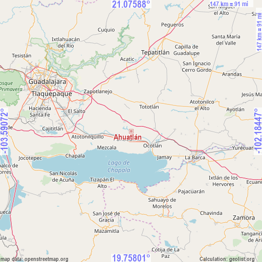
Ahuatlán GPS coordinates[2]
20° 25' 6.096" North, 102° 53' 15.324" West
| Map corner | latitude | longitude |
|---|---|---|
| Upper-left | 21.07588°, | -103.59072° |
| Center: | 20.41836°, | -102.88759° |
| Lower-right: | 19.75801°, | -102.18447° |
| Map W x H: | 146.5×146.5 km | = 91×91mi |
| max Lat: | 32.7° ⇑34% North |
| Ahuatlán: | 20.41836° |
| min Lat: | ⇓66% South 14.53588° |
| min Long | Ahuatlán | max Long |
| -117.105° | -102.88759° | -86.73105° |
| W 14.6%⇐ | ⇒85.4% E |
Elevation
Elevation of Ahuatlán is 1544 m = 5066 ft, and this is 290.3 m = 952 ft above average elevation for this country.
| Max E: |
3497 m = 11473 ft | 46.8% |
| Ahuatlán | 1544 m 5066 ft | |
| Avg. | 1253.7 m = 4113 ft | |
Min E: |
-1 m = -3 ft | 53.2% |
See also: Mexico elevation on elevation.city.
Geographical zone
Ahuatlán is located in North Torrid zone (between Equator and Tropic of Cancer). Distance of this Northern Tropic circle is 335.6 km =208.5 mi to North.| Distance of | km | miles | from Ahuatlán |
|---|---|---|---|
| North Pole | 7736.8 | 4807.4 | to North |
| Arctic Circle | 5130.9 | 3188.2 | to North |
| Tropic Cancer | 335.6 | 208.5 | to North |
| Equator | 2270.3 | 1410.7 | to South |


Nearby cities:
15 places around Ahuatlán: (largest is in red/bold)
• Chalpicote
12.4 km =7.7 mi,  193°
193°
• Chila
9.8 km =6.1 mi,  298°
298°
• El Romereño (INFONAVIT)
7.7 km =4.8 mi,  237°
237°
• El Sauz
11.2 km =7 mi,  53°
53°
• La Colonia
4.6 km =2.9 mi,  282°
282°
• La Noria
5.9 km =3.7 mi, 46°
• La Zapotera
12.5 km =7.8 mi,  184°
184°
• Los Cerritos
13.4 km =8.3 mi,  60°
60°
• Otatlán
9.1 km =5.7 mi,  74°
74°
• Poncitlán
5.8 km =3.6 mi,  222°
222°
• San Luis de Agua Caliente
7.7 km =4.8 mi,  120°
120°
• San Miguel Zapotitlán
11.5 km =7.1 mi,  254°
254°
• San Pedro Itzicán
13.2 km =8.2 mi,  211°
211°
• Santa Cruz el Grande
5.4 km =3.4 mi,  152°
152°
• Zapotlán del Rey
6.7 km =4.2 mi,  323°
323°
Sources, notices
• [Note1] Compared only with cities in Mexico existing in our database
• [Src1] Map data: © OpenStreetMap contributors (CC-BY-SA)
• [Src2] Other city data from geonames.org with taken over terms of usage.
• [Src3] Geographical zone / Annual Mean Temperature by Robert A. Rohde @ Wikipedia
