Chimalapa geodata
Chimalapa (Hidalgo) is a populated place; located in Mexico in America/Mexico_City (GMT-6) time zone. With population of 2,008 people, there are 4332 cities with bigger population in this country. Compared to other cities in Mexico, 61.1% of cities are located further ↓South; 61.8% of cities are located further ←West and 75.8% of cities have lower elevation than Chimalapa. Note1


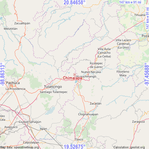
Chimalapa GPS coordinates[2]
20° 11' 17.016" North, 98° 9' 36" West
| Map corner | latitude | longitude |
|---|---|---|
| Upper-left | 20.84658°, | -98.86313° |
| Center: | 20.18806°, | -98.16° |
| Lower-right: | 19.52675°, | -97.45688° |
| Map W x H: | 146.8×146.8 km | = 91.2×91.2mi |
| max Lat: | 32.7° ⇑38.9% North |
| Chimalapa: | 20.18806° |
| min Lat: | ⇓61.1% South 14.53588° |
| min Long | Chimalapa | max Long |
| -117.105° | -98.16° | -86.73105° |
| W 61.8%⇐ | ⇒38.2% E |
Elevation
Elevation of Chimalapa is 2044 m = 6706 ft, and this is 790.3 m = 2593 ft above average elevation for this country.
| Max E: |
3497 m = 11473 ft | 24.2% |
| Chimalapa | 2044 m 6706 ft | |
| Avg. | 1253.7 m = 4113 ft | |
Min E: |
-1 m = -3 ft | 75.8% |
See also: Mexico elevation on elevation.city.
Geographical zone
Chimalapa is located in North Torrid zone (between Equator and Tropic of Cancer). Distance of this Northern Tropic circle is 361.2 km =224.4 mi to North.| Distance of | km | miles | from Chimalapa |
|---|---|---|---|
| North Pole | 7762.4 | 4823.3 | to North |
| Arctic Circle | 5156.5 | 3204.1 | to North |
| Tropic Cancer | 361.2 | 224.4 | to North |
| Equator | 2244.7 | 1394.8 | to South |


Nearby cities:
15 places around Chimalapa: (largest is in red/bold)
• Acaxochitlán
5.5 km =3.4 mi,  232°
232°
• Barrio Techachalco
6.3 km =3.9 mi,  243°
243°
• Chachahuantla
3.2 km =2 mi,  61°
61°
• Cuahuihuitzotitla
4.6 km =2.9 mi,  73°
73°
• El Tejocotal
6.3 km =3.9 mi,  147°
147°
• Los Reyes
3.7 km =2.3 mi,  186°
186°
• Naupan
7.2 km =4.5 mi,  48°
48°
• San Francisco Atotonilco
1.1 km =0.7 mi, 49°
• San Miguel del Resgate
4.8 km =3 mi,  340°
340°
• Santa Ana Tzacuala
4.7 km =2.9 mi,  283°
283°
• Tepepa
6.1 km =3.8 mi, 191°
• Tlacomulco
5.7 km =3.5 mi,  133°
133°
• Tlaltegco (Venta Quemada)
5.8 km =3.6 mi,  214°
214°
• Tlatzintla
4.7 km =2.9 mi,  221°
221°
• Tlaxpanaloya
5.9 km =3.7 mi,  44°
44°
Sources, notices
• [Note1] Compared only with cities in Mexico existing in our database
• [Src1] Map data: © OpenStreetMap contributors (CC-BY-SA)
• [Src2] Other city data from geonames.org with taken over terms of usage.
• [Src3] Geographical zone / Annual Mean Temperature by Robert A. Rohde @ Wikipedia
