Tlacomulco geodata
Tlacomulco (Hidalgo) is a populated place; located in Mexico in America/Mexico_City (GMT-6) time zone. With population of 1,932 people, there are 4505 cities with bigger population in this country. Compared to other cities in Mexico, 60.3% of cities are located further ↓South; 62.3% of cities are located further ←West and 78.7% of cities have lower elevation than Tlacomulco. Note1


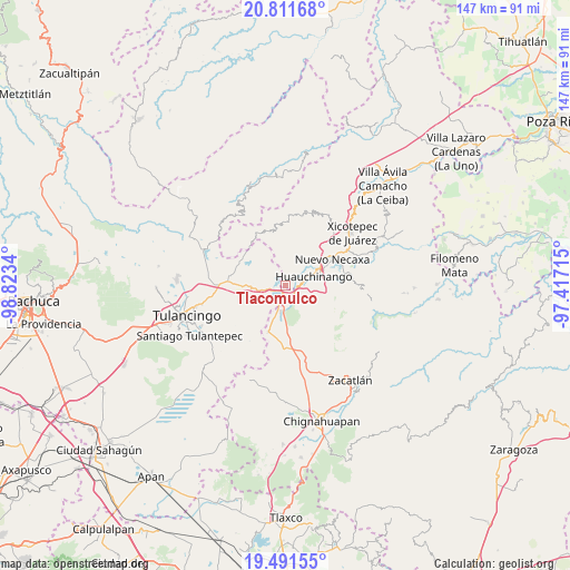
Tlacomulco GPS coordinates[2]
20° 9' 10.836" North, 98° 7' 12.972" West
| Map corner | latitude | longitude |
|---|---|---|
| Upper-left | 20.81168°, | -98.8234° |
| Center: | 20.15301°, | -98.12027° |
| Lower-right: | 19.49155°, | -97.41715° |
| Map W x H: | 146.8×146.8 km | = 91.2×91.2mi |
| max Lat: | 32.7° ⇑39.7% North |
| Tlacomulco: | 20.15301° |
| min Lat: | ⇓60.3% South 14.53588° |
| min Long | Tlacomulco | max Long |
| -117.105° | -98.12027° | -86.73105° |
| W 62.3%⇐ | ⇒37.7% E |
Elevation
Elevation of Tlacomulco is 2105 m = 6906 ft, and this is 851.3 m = 2793 ft above average elevation for this country.
| Max E: |
3497 m = 11473 ft | 21.3% |
| Tlacomulco | 2105 m 6906 ft | |
| Avg. | 1253.7 m = 4113 ft | |
Min E: |
-1 m = -3 ft | 78.7% |
See also: Mexico elevation on elevation.city.
Geographical zone
Tlacomulco is located in North Torrid zone (between Equator and Tropic of Cancer). Distance of this Northern Tropic circle is 365.1 km =226.9 mi to North.| Distance of | km | miles | from Tlacomulco |
|---|---|---|---|
| North Pole | 7766.3 | 4825.8 | to North |
| Arctic Circle | 5160.4 | 3206.5 | to North |
| Tropic Cancer | 365.1 | 226.9 | to North |
| Equator | 2240.8 | 1392.4 | to South |


Nearby cities:
15 places around Tlacomulco: (largest is in red/bold)
• Beristain
6.7 km =4.2 mi,  191°
191°
• Chachahuantla
5.6 km =3.5 mi,  346°
346°
• Chimalapa
5.7 km =3.5 mi,  313°
313°
• Cuahuihuitzotitla
5.2 km =3.2 mi,  3°
3°
• El Tejocotal
1.6 km =1 mi,  206°
206°
• Huauchinango
7.2 km =4.5 mi,  71°
71°
• Huilacapixtla
7.7 km =4.8 mi,  31°
31°
• La Boveda
3.2 km =2 mi, 188°
• Los Reyes
4.6 km =2.9 mi,  273°
273°
• Mesa de Capulines
4.5 km =2.8 mi,  177°
177°
• San Francisco Atotonilco
5.7 km =3.5 mi,  324°
324°
• Tepepa
5.7 km =3.5 mi,  248°
248°
• Tlaltegco (Venta Quemada)
7.5 km =4.7 mi,  262°
262°
• Tlatzintla
7.3 km =4.5 mi, 272°
• Venta Grande
4.4 km =2.7 mi,  150°
150°
Sources, notices
• [Note1] Compared only with cities in Mexico existing in our database
• [Src1] Map data: © OpenStreetMap contributors (CC-BY-SA)
• [Src2] Other city data from geonames.org with taken over terms of usage.
• [Src3] Geographical zone / Annual Mean Temperature by Robert A. Rohde @ Wikipedia
