Tonayán geodata
Tonayán (Veracruz) is a seat of a second-order administrative division; located in Mexico in America/Mexico_City (GMT-6) time zone. With population of 1,446 people, there are 5968 cities with bigger population in this country. Compared to other cities in Mexico, 50% of cities are located further ↓South; 75.9% of cities are located further ←West and 65% of cities have lower elevation than Tonayán. Note1


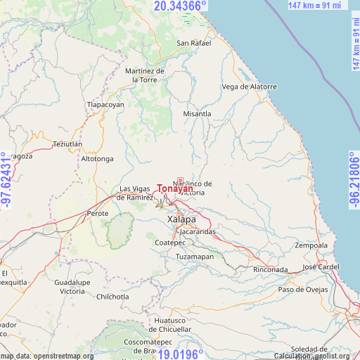
Tonayán GPS coordinates[2]
19° 40' 58.8" North, 96° 55' 16.248" West
| Map corner | latitude | longitude |
|---|---|---|
| Upper-left | 20.34366°, | -97.62431° |
| Center: | 19.683°, | -96.92118° |
| Lower-right: | 19.0196°, | -96.21806° |
| Map W x H: | 147.2×147.2 km | = 91.5×91.5mi |
| max Lat: | 32.7° ⇑50% North |
| Tonayán: | 19.683° |
| min Lat: | ⇓50% South 14.53588° |
| min Long | Tonayán | max Long |
| -117.105° | -96.92118° | -86.73105° |
| W 75.9%⇐ | ⇒24.1% E |
Elevation
Elevation of Tonayán is 1830 m = 6004 ft, and this is 576.3 m = 1891 ft above average elevation for this country.
| Max E: |
3497 m = 11473 ft | 35% |
| Tonayán | 1830 m 6004 ft | |
| Avg. | 1253.7 m = 4113 ft | |
Min E: |
-1 m = -3 ft | 65% |
See also: Mexico elevation on elevation.city.
Geographical zone
Tonayán is located in North Torrid zone (between Equator and Tropic of Cancer). Distance of this Northern Tropic circle is 417.4 km =259.4 mi to North.| Distance of | km | miles | from Tonayán |
|---|---|---|---|
| North Pole | 7818.5 | 4858.2 | to North |
| Arctic Circle | 5212.6 | 3239 | to North |
| Tropic Cancer | 417.4 | 259.4 | to North |
| Equator | 2188.5 | 1359.9 | to South |


Nearby cities:
15 places around Tonayán: (largest is in red/bold)
• Acatlán
8.4 km =5.2 mi,  79°
79°
• Coacoatzintla
4 km =2.5 mi,  210°
210°
• Duraznal
7.9 km =4.9 mi,  249°
249°
• El Espinal
8.3 km =5.2 mi,  141°
141°
• El Fresno
8.2 km =5.1 mi,  232°
232°
• Etlantepec
6.8 km =4.2 mi,  272°
272°
• Jilotepec
8.5 km =5.3 mi,  201°
201°
• Las Lomas
6.7 km =4.2 mi,  171°
171°
• Linderos
8.4 km =5.2 mi,  218°
218°
• Los Planes (Cerro Gordo)
2.3 km =1.4 mi, 195°
• Miahuatlán
6 km =3.7 mi,  62°
62°
• Naolinco de Victoria
5.9 km =3.7 mi,  122°
122°
• Piedras Grandes
2 km =1.2 mi,  15°
15°
• Puentezuelos
3.4 km =2.1 mi,  349°
349°
• San Marcos Atesquilapan
3.8 km =2.4 mi, 78°
Sources, notices
• [Note1] Compared only with cities in Mexico existing in our database
• [Src1] Map data: © OpenStreetMap contributors (CC-BY-SA)
• [Src2] Other city data from geonames.org with taken over terms of usage.
• [Src3] Geographical zone / Annual Mean Temperature by Robert A. Rohde @ Wikipedia
