San José Neria geodata
San José Neria (Veracruz) is a populated place; located in Mexico in America/Mexico_City (GMT-6) time zone. With population of 1,698 people, there are 5116 cities with bigger population in this country. Compared to other cities in Mexico, 64.8% of cities are located further ↑North; 74.9% of cities are located further ←West and 54.7% of cities have higher elevation than San José Neria. Note1


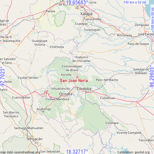
San José Neria GPS coordinates[2]
18° 59' 35.988" North, 96° 59' 57.012" West
| Map corner | latitude | longitude |
|---|---|---|
| Upper-left | 19.65683°, | -97.7023° |
| Center: | 18.99333°, | -96.99917° |
| Lower-right: | 18.32717°, | -96.29605° |
| Map W x H: | 147.8×147.8 km | = 91.8×91.8mi |
| max Lat: | 32.7° ⇑64.8% North |
| San José Neria: | 18.99333° |
| min Lat: | ⇓35.2% South 14.53588° |
| min Long | San José Neria | max Long |
| -117.105° | -96.99917° | -86.73105° |
| W 74.9%⇐ | ⇒25.1% E |
Elevation
Elevation of San José Neria is 1210 m = 3970 ft, and this is 43.7 m = 143 ft below average elevation for this country.
| Max E: |
3497 m = 11473 ft | 54.7% |
| Avg. | 1253.7 m = 4113 ft | |
| San José Neria | 1210 m = 3970 ft | |
Min E: |
-1 m = -3 ft | 45.3% |
See also: Mexico elevation on elevation.city.
Geographical zone
San José Neria is located in North Torrid zone (between Equator and Tropic of Cancer). Distance of this Northern Tropic circle is 494.1 km =307 mi to North.| Distance of | km | miles | from San José Neria |
|---|---|---|---|
| North Pole | 7895.2 | 4905.8 | to North |
| Arctic Circle | 5289.3 | 3286.6 | to North |
| Tropic Cancer | 494.1 | 307 | to North |
| Equator | 2111.9 | 1312.3 | to South |


Nearby cities:
15 places around San José Neria: (largest is in red/bold)
• Calaquioco
5.6 km =3.5 mi,  317°
317°
• Chocamán
4.1 km =2.5 mi,  300°
300°
• Dos Ríos
6.1 km =3.8 mi,  210°
210°
• El Palenque Palotal
3.5 km =2.2 mi,  143°
143°
• Ixcapantla
4.7 km =2.9 mi,  39°
39°
• La Palma (Tercera Manzana del Barreal)
6 km =3.7 mi,  164°
164°
• Monte Blanco
3.5 km =2.2 mi, 211°
• Rincón Pintor
6.3 km =3.9 mi,  272°
272°
• Santa Lucía Potrerillo
3.8 km =2.4 mi,  224°
224°
• Tecama
1.9 km =1.2 mi,  51°
51°
• Tecama Calería (Sabana Larga)
2.7 km =1.7 mi,  125°
125°
• Tecamilla
1.5 km =0.9 mi,  74°
74°
• Tocuila
5.2 km =3.2 mi,  200°
200°
• Tomatlán
4.3 km =2.7 mi,  344°
344°
• Xonotzintla
4.7 km =2.9 mi,  277°
277°
Sources, notices
• [Note1] Compared only with cities in Mexico existing in our database
• [Src1] Map data: © OpenStreetMap contributors (CC-BY-SA)
• [Src2] Other city data from geonames.org with taken over terms of usage.
• [Src3] Geographical zone / Annual Mean Temperature by Robert A. Rohde @ Wikipedia
