Chocamán geodata
Chocamán (Veracruz) is a seat of a second-order administrative division; located in Mexico in America/Mexico_City (GMT-6) time zone. With population of 10,727 people, there are 887 cities with bigger population in this country. Compared to other cities in Mexico, 64.5% of cities are located further ↑North; 74.4% of cities are located further ←West and 51.6% of cities have higher elevation than Chocamán. Note1


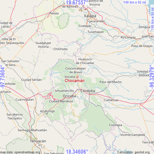
Chocamán GPS coordinates[2]
19° 0' 43.704" North, 97° 1' 58.476" West
| Map corner | latitude | longitude |
|---|---|---|
| Upper-left | 19.67557°, | -97.73604° |
| Center: | 19.01214°, | -97.03291° |
| Lower-right: | 18.34606°, | -96.32979° |
| Map W x H: | 147.8×147.8 km | = 91.8×91.8mi |
| max Lat: | 32.7° ⇑64.5% North |
| Chocamán: | 19.01214° |
| min Lat: | ⇓35.5% South 14.53588° |
| min Long | Chocamán | max Long |
| -117.105° | -97.03291° | -86.73105° |
| W 74.4%⇐ | ⇒25.6% E |
Elevation
Elevation of Chocamán is 1358 m = 4455 ft, and this is 104.3 m = 342 ft above average elevation for this country.
| Max E: |
3497 m = 11473 ft | 51.6% |
| Chocamán | 1358 m 4455 ft | |
| Avg. | 1253.7 m = 4113 ft | |
Min E: |
-1 m = -3 ft | 48.4% |
See also: Mexico elevation on elevation.city.
Geographical zone
Chocamán is located in North Torrid zone (between Equator and Tropic of Cancer). Distance of this Northern Tropic circle is 492 km =305.7 mi to North.| Distance of | km | miles | from Chocamán |
|---|---|---|---|
| North Pole | 7893.1 | 4904.5 | to North |
| Arctic Circle | 5287.2 | 3285.3 | to North |
| Tropic Cancer | 492 | 305.7 | to North |
| Equator | 2114 | 1313.6 | to South |


Nearby cities:
15 places around Chocamán: (largest is in red/bold)
• Calaquioco
2.1 km =1.3 mi,  354°
354°
• Gonzalo Vázquez Vela
5.3 km =3.3 mi,  338°
338°
• Huilotla
6 km =3.7 mi,  285°
285°
• Monte Blanco
5.4 km =3.4 mi,  161°
161°
• Nicanor Espejo
5.7 km =3.5 mi, 344°
• Rincón Pintor
3.3 km =2.1 mi,  236°
236°
• San José Neria
4.1 km =2.5 mi,  120°
120°
• Santa Lucía Potrerillo
4.9 km =3 mi,  169°
169°
• Tecama
5.1 km =3.2 mi,  100°
100°
• Tecamilla
5.3 km =3.3 mi,  108°
108°
• Tetla
4 km =2.5 mi,  226°
226°
• Tetlaxco
4.5 km =2.8 mi,  313°
313°
• Tomatlán
3.2 km =2 mi,  49°
49°
• Xalatlaco
4.3 km =2.7 mi, 348°
• Xonotzintla
1.8 km =1.1 mi,  216°
216°
Sources, notices
• [Note1] Compared only with cities in Mexico existing in our database
• [Src1] Map data: © OpenStreetMap contributors (CC-BY-SA)
• [Src2] Other city data from geonames.org with taken over terms of usage.
• [Src3] Geographical zone / Annual Mean Temperature by Robert A. Rohde @ Wikipedia
