Ixcapantla geodata
Ixcapantla (Veracruz) is a populated place; located in Mexico in America/Mexico_City (GMT-6) time zone. With population of 1,018 people, there are 8556 cities with bigger population in this country. Compared to other cities in Mexico, 64.2% of cities are located further ↑North; 75.3% of cities are located further ←West and 51.7% of cities have higher elevation than Ixcapantla. Note1


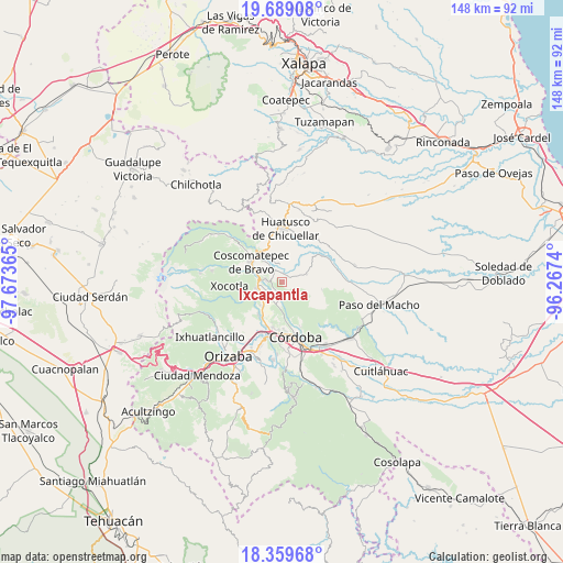
Ixcapantla GPS coordinates[2]
19° 1' 32.556" North, 96° 58' 13.872" West
| Map corner | latitude | longitude |
|---|---|---|
| Upper-left | 19.68908°, | -97.67365° |
| Center: | 19.02571°, | -96.97052° |
| Lower-right: | 18.35968°, | -96.2674° |
| Map W x H: | 147.8×147.8 km | = 91.8×91.8mi |
| max Lat: | 32.7° ⇑64.2% North |
| Ixcapantla: | 19.02571° |
| min Lat: | ⇓35.8% South 14.53588° |
| min Long | Ixcapantla | max Long |
| -117.105° | -96.97052° | -86.73105° |
| W 75.3%⇐ | ⇒24.7% E |
Elevation
Elevation of Ixcapantla is 1354 m = 4442 ft, and this is 100.3 m = 329 ft above average elevation for this country.
| Max E: |
3497 m = 11473 ft | 51.7% |
| Ixcapantla | 1354 m 4442 ft | |
| Avg. | 1253.7 m = 4113 ft | |
Min E: |
-1 m = -3 ft | 48.3% |
See also: Mexico elevation on elevation.city.
Geographical zone
Ixcapantla is located in North Torrid zone (between Equator and Tropic of Cancer). Distance of this Northern Tropic circle is 490.5 km =304.8 mi to North.| Distance of | km | miles | from Ixcapantla |
|---|---|---|---|
| North Pole | 7891.6 | 4903.6 | to North |
| Arctic Circle | 5285.7 | 3284.4 | to North |
| Tropic Cancer | 490.5 | 304.8 | to North |
| Equator | 2115.5 | 1314.5 | to South |


Nearby cities:
15 places around Ixcapantla: (largest is in red/bold)
• Calaquioco
6.8 km =4.2 mi,  274°
274°
• Chocamán
6.7 km =4.2 mi,  257°
257°
• El Bajío
4.9 km =3 mi,  116°
116°
• El Palenque Palotal
6.5 km =4 mi,  188°
188°
• Guzmantla
5.1 km =3.2 mi,  105°
105°
• Ixhuatlán del Café
3.2 km =2 mi,  333°
333°
• Ocotitlán
6.8 km =4.2 mi,  74°
74°
• Presidio
4.9 km =3 mi,  358°
358°
• San José Loma Grande
4.9 km =3 mi,  134°
134°
• San José Neria
4.7 km =2.9 mi,  219°
219°
• Tecama
2.9 km =1.8 mi,  212°
212°
• Tecama Calería (Sabana Larga)
5.2 km =3.2 mi, 188°
• Tecamilla
3.6 km =2.2 mi, 206°
• Tomatlán
4.2 km =2.6 mi,  278°
278°
• Zacamitla
5.6 km =3.5 mi,  60°
60°
Sources, notices
• [Note1] Compared only with cities in Mexico existing in our database
• [Src1] Map data: © OpenStreetMap contributors (CC-BY-SA)
• [Src2] Other city data from geonames.org with taken over terms of usage.
• [Src3] Geographical zone / Annual Mean Temperature by Robert A. Rohde @ Wikipedia
