Santa Lucía Potrerillo geodata
Santa Lucía Potrerillo (Veracruz) is a populated place; located in Mexico in America/Mexico_City (GMT-6) time zone. With population of 1,609 people, there are 5377 cities with bigger population in this country. Compared to other cities in Mexico, 65.3% of cities are located further ↑North; 74.5% of cities are located further ←West and 52.9% of cities have higher elevation than Santa Lucía Potrerillo. Note1


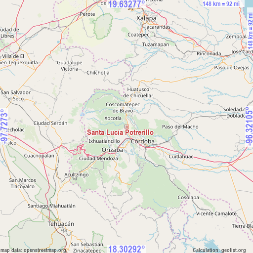
Santa Lucía Potrerillo GPS coordinates[2]
18° 58' 9.012" North, 97° 1' 27.012" West
| Map corner | latitude | longitude |
|---|---|---|
| Upper-left | 19.63277°, | -97.7273° |
| Center: | 18.96917°, | -97.02417° |
| Lower-right: | 18.30292°, | -96.32105° |
| Map W x H: | 147.9×147.9 km | = 91.9×91.9mi |
| max Lat: | 32.7° ⇑65.3% North |
| Santa Lucía Potrerillo: | 18.96917° |
| min Lat: | ⇓34.7% South 14.53588° |
| min Long | Santa Lucía Po | max Long |
| -117.105° | -97.02417° | -86.73105° |
| W 74.5%⇐ | ⇒25.5% E |
Elevation
Elevation of Santa Lucía Potrerillo is 1292 m = 4239 ft, and this is 38.3 m = 126 ft above average elevation for this country.
| Max E: |
3497 m = 11473 ft | 52.9% |
| Santa Lucía Potrerillo | 1292 m 4239 ft | |
| Avg. | 1253.7 m = 4113 ft | |
Min E: |
-1 m = -3 ft | 47.1% |
See also: Mexico elevation on elevation.city.
Geographical zone
Santa Lucía Potrerillo is located in North Torrid zone (between Equator and Tropic of Cancer). Distance of this Northern Tropic circle is 496.7 km =308.6 mi to North.| Distance of | km | miles | from Santa Lucía Potrerillo |
|---|---|---|---|
| North Pole | 7897.9 | 4907.5 | to North |
| Arctic Circle | 5292 | 3288.3 | to North |
| Tropic Cancer | 496.7 | 308.6 | to North |
| Equator | 2109.2 | 1310.6 | to South |


Nearby cities:
15 places around Santa Lucía Potrerillo: (largest is in red/bold)
• Chocamán
4.9 km =3 mi,  349°
349°
• Cumbre de Metlac
4.8 km =3 mi,  182°
182°
• Dos Ríos
2.7 km =1.7 mi,  189°
189°
• El Palenque Palotal
4.7 km =2.9 mi,  91°
91°
• La Palma (Tercera Manzana del Barreal)
5.2 km =3.2 mi,  126°
126°
• Monte Blanco
0.8 km =0.5 mi,  111°
111°
• Monte Salas
3.6 km =2.2 mi,  170°
170°
• Rincón Pintor
4.7 km =2.9 mi,  309°
309°
• San José Neria
3.8 km =2.4 mi,  44°
44°
• Tecama
5.6 km =3.5 mi,  46°
46°
• Tecama Calería (Sabana Larga)
5 km =3.1 mi,  77°
77°
• Tecamilla
5.1 km =3.2 mi, 52°
• Tetla
4.3 km =2.7 mi,  297°
297°
• Tocuila
2.3 km =1.4 mi,  159°
159°
• Xonotzintla
3.9 km =2.4 mi,  328°
328°
Sources, notices
• [Note1] Compared only with cities in Mexico existing in our database
• [Src1] Map data: © OpenStreetMap contributors (CC-BY-SA)
• [Src2] Other city data from geonames.org with taken over terms of usage.
• [Src3] Geographical zone / Annual Mean Temperature by Robert A. Rohde @ Wikipedia
