Tecama geodata
Tecama (Veracruz) is a populated place; located in Mexico in America/Mexico_City (GMT-6) time zone. With population of 1,086 people, there are 8018 cities with bigger population in this country. Compared to other cities in Mexico, 64.6% of cities are located further ↑North; 75% of cities are located further ←West and 55.1% of cities have higher elevation than Tecama. Note1


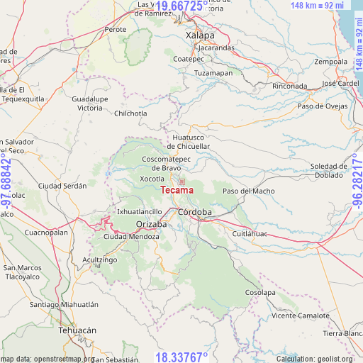
Tecama GPS coordinates[2]
19° 0' 13.644" North, 96° 59' 7.044" West
| Map corner | latitude | longitude |
|---|---|---|
| Upper-left | 19.66725°, | -97.68842° |
| Center: | 19.00379°, | -96.98529° |
| Lower-right: | 18.33767°, | -96.28217° |
| Map W x H: | 147.8×147.8 km | = 91.8×91.8mi |
| max Lat: | 32.7° ⇑64.6% North |
| Tecama: | 19.00379° |
| min Lat: | ⇓35.4% South 14.53588° |
| min Long | Tecama | max Long |
| -117.105° | -96.98529° | -86.73105° |
| W 75%⇐ | ⇒25% E |
Elevation
Elevation of Tecama is 1192 m = 3911 ft, and this is 61.7 m = 202 ft below average elevation for this country.
| Max E: |
3497 m = 11473 ft | 55.1% |
| Avg. | 1253.7 m = 4113 ft | |
| Tecama | 1192 m = 3911 ft | |
Min E: |
-1 m = -3 ft | 44.9% |
See also: Mexico elevation on elevation.city.
Geographical zone
Tecama is located in North Torrid zone (between Equator and Tropic of Cancer). Distance of this Northern Tropic circle is 492.9 km =306.3 mi to North.| Distance of | km | miles | from Tecama |
|---|---|---|---|
| North Pole | 7894 | 4905.1 | to North |
| Arctic Circle | 5288.2 | 3285.9 | to North |
| Tropic Cancer | 492.9 | 306.3 | to North |
| Equator | 2113 | 1313 | to South |


Nearby cities:
15 places around Tecama: (largest is in red/bold)
• Calaquioco
6 km =3.7 mi,  299°
299°
• Chocamán
5.1 km =3.2 mi,  280°
280°
• El Bajío
6 km =3.7 mi,  87°
87°
• El Palenque Palotal
4.1 km =2.5 mi,  170°
170°
• Guzmantla
6.6 km =4.1 mi,  80°
80°
• Ixcapantla
2.9 km =1.8 mi,  32°
32°
• Ixhuatlán del Café
5.3 km =3.3 mi,  1°
1°
• Monte Blanco
5.3 km =3.3 mi,  218°
218°
• San José Loma Grande
5.2 km =3.2 mi,  101°
101°
• San José Neria
1.9 km =1.2 mi,  231°
231°
• Santa Lucía Potrerillo
5.6 km =3.5 mi, 226°
• Tecama Calería (Sabana Larga)
2.9 km =1.8 mi,  164°
164°
• Tecamilla
0.8 km =0.5 mi,  182°
182°
• Tomatlán
4 km =2.5 mi,  319°
319°
• Xonotzintla
6.1 km =3.8 mi,  264°
264°
Sources, notices
• [Note1] Compared only with cities in Mexico existing in our database
• [Src1] Map data: © OpenStreetMap contributors (CC-BY-SA)
• [Src2] Other city data from geonames.org with taken over terms of usage.
• [Src3] Geographical zone / Annual Mean Temperature by Robert A. Rohde @ Wikipedia
