La Candelaria geodata
La Candelaria (Chiapas) is a populated place; located in Mexico in America/Mexico_City (GMT-6) time zone. With population of 1,955 people, there are 4454 cities with bigger population in this country. Compared to other cities in Mexico, 92.4% of cities are located further ↑North; 91.7% of cities are located further ←West and 90% of cities have lower elevation than La Candelaria. Note1


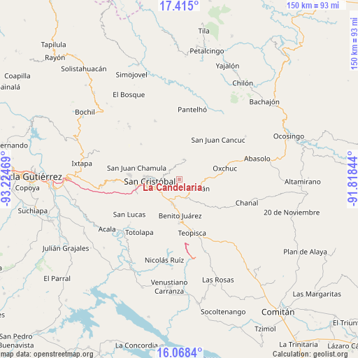
La Candelaria GPS coordinates[2]
16° 44' 34.404" North, 92° 31' 17.616" West
| Map corner | latitude | longitude |
|---|---|---|
| Upper-left | 17.415°, | -93.22469° |
| Center: | 16.74289°, | -92.52156° |
| Lower-right: | 16.0684°, | -91.81844° |
| Map W x H: | 149.7×149.7 km | = 93×93mi |
| max Lat: | 32.7° ⇑92.4% North |
| La Candelaria: | 16.74289° |
| min Lat: | ⇓7.6% South 14.53588° |
| min Long | La Candelaria | max Long |
| -117.105° | -92.52156° | -86.73105° |
| W 91.7%⇐ | ⇒8.3% E |
Elevation
Elevation of La Candelaria is 2408 m = 7900 ft, and this is 1154.3 m = 3787 ft above average elevation for this country.
| Max E: |
3497 m = 11473 ft | 10% |
| La Candelaria | 2408 m 7900 ft | |
| Avg. | 1253.7 m = 4113 ft | |
Min E: |
-1 m = -3 ft | 90% |
See also: Mexico elevation on elevation.city.
Geographical zone
La Candelaria is located in North Torrid zone (between Equator and Tropic of Cancer). Distance of this Northern Tropic circle is 744.3 km =462.5 mi to North.| Distance of | km | miles | from La Candelaria |
|---|---|---|---|
| North Pole | 8145.4 | 5061.3 | to North |
| Arctic Circle | 5539.5 | 3442.1 | to North |
| Tropic Cancer | 744.3 | 462.5 | to North |
| Equator | 1861.6 | 1156.7 | to South |


Nearby cities:
15 places around La Candelaria: (largest is in red/bold)
• Agua de Pajarito
4.9 km =3 mi,  261°
261°
• Chilimjoveltic
7.9 km =4.9 mi,  309°
309°
• Corazón de María
5 km =3.1 mi,  195°
195°
• Cruztón
6.5 km =4 mi,  288°
288°
• El Crucero
8 km =5 mi,  323°
323°
• El Escalón
4.1 km =2.5 mi,  174°
174°
• Eshpuilho
6.1 km =3.8 mi,  125°
125°
• Jocosic
7.3 km =4.5 mi,  71°
71°
• La Sierra
4 km =2.5 mi,  214°
214°
• La Soledad
7.4 km =4.6 mi,  178°
178°
• Las Ollas
5.4 km =3.4 mi, 322°
• Matzam
7 km =4.3 mi,  42°
42°
• Oquem
5 km =3.1 mi,  114°
114°
• Romerillo
5.5 km =3.4 mi,  296°
296°
• San Pedro la Tejería
2 km =1.2 mi,  142°
142°
Sources, notices
• [Note1] Compared only with cities in Mexico existing in our database
• [Src1] Map data: © OpenStreetMap contributors (CC-BY-SA)
• [Src2] Other city data from geonames.org with taken over terms of usage.
• [Src3] Geographical zone / Annual Mean Temperature by Robert A. Rohde @ Wikipedia
