San Lorenzo geodata
San Lorenzo (Michoacán) is a populated place; located in Mexico in America/Mexico_City (GMT-6) time zone. With population of 1,598 people, there are 5410 cities with bigger population in this country. Compared to other cities in Mexico, 56.8% of cities are located further ↓South; 78.6% of cities are located further →East and 73.1% of cities have lower elevation than San Lorenzo. Note1


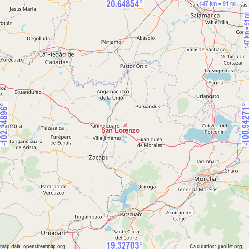
San Lorenzo GPS coordinates[2]
19° 59' 21.012" North, 101° 38' 44.988" West
| Map corner | latitude | longitude |
|---|---|---|
| Upper-left | 20.64854°, | -102.34896° |
| Center: | 19.98917°, | -101.64583° |
| Lower-right: | 19.32703°, | -100.94271° |
| Map W x H: | 146.9×146.9 km | = 91.3×91.3mi |
| max Lat: | 32.7° ⇑43.2% North |
| San Lorenzo: | 19.98917° |
| min Lat: | ⇓56.8% South 14.53588° |
| min Long | San Lorenzo | max Long |
| -117.105° | -101.64583° | -86.73105° |
| W 21.4%⇐ | ⇒78.6% E |
Elevation
Elevation of San Lorenzo is 1991 m = 6532 ft, and this is 737.3 m = 2419 ft above average elevation for this country.
| Max E: |
3497 m = 11473 ft | 26.9% |
| San Lorenzo | 1991 m 6532 ft | |
| Avg. | 1253.7 m = 4113 ft | |
Min E: |
-1 m = -3 ft | 73.1% |
See also: Mexico elevation on elevation.city.
Geographical zone
San Lorenzo is located in North Torrid zone (between Equator and Tropic of Cancer). Distance of this Northern Tropic circle is 383.3 km =238.2 mi to North.| Distance of | km | miles | from San Lorenzo |
|---|---|---|---|
| North Pole | 7784.5 | 4837.1 | to North |
| Arctic Circle | 5178.6 | 3217.8 | to North |
| Tropic Cancer | 383.3 | 238.2 | to North |
| Equator | 2222.6 | 1381.1 | to South |


Nearby cities:
15 places around San Lorenzo: (largest is in red/bold)
• Agua Caliente
12.6 km =7.8 mi,  312°
312°
• Copándaro (Copándaro del Cuatro)
10 km =6.2 mi,  188°
188°
• Curimeo
6.2 km =3.9 mi,  303°
303°
• El Fresno de la Reforma
12.8 km =8 mi,  254°
254°
• Galeana
9.3 km =5.8 mi,  56°
56°
• J. Trinidad Regalado (La Colonia)
11.7 km =7.3 mi,  292°
292°
• La Estancia del Río
11.2 km =7 mi,  323°
323°
• La Luz
1.3 km =0.8 mi,  224°
224°
• Las Colonias
11.5 km =7.1 mi, 221°
• Nuevo Progreso (Casas Viejas)
6.6 km =4.1 mi,  355°
355°
• Panindícuaro
12 km =7.5 mi,  267°
267°
• Sabino Buenavista
11.5 km =7.1 mi,  31°
31°
• San Miguel
5.6 km =3.5 mi,  0°
0°
• Urequío
4.6 km =2.9 mi, 253°
• Ururuta
7.4 km =4.6 mi, 33°
Sources, notices
• [Note1] Compared only with cities in Mexico existing in our database
• [Src1] Map data: © OpenStreetMap contributors (CC-BY-SA)
• [Src2] Other city data from geonames.org with taken over terms of usage.
• [Src3] Geographical zone / Annual Mean Temperature by Robert A. Rohde @ Wikipedia
