Urequío geodata
Urequío (Michoacán) is a populated place; located in Mexico in America/Mexico_City (GMT-6) time zone. With population of 709 people, there are 12279 cities with bigger population in this country. Compared to other cities in Mexico, 56.5% of cities are located further ↓South; 78.9% of cities are located further →East and 69.9% of cities have lower elevation than Urequío. Note1


Urequío GPS coordinates[2]
19° 58' 39" North, 101° 41' 17.988" West
| Map corner | latitude | longitude |
|---|---|---|
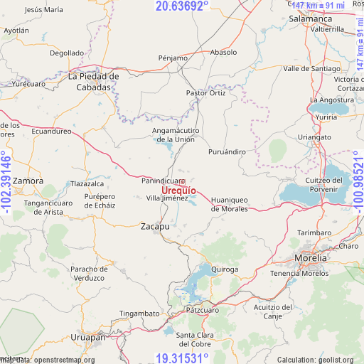
| Upper-left | 20.63692°, | -102.39146° |
| Center: | 19.9775°, | -101.68833° |
| Lower-right: | 19.31531°, | -100.98521° |
| Map W x H: | 146.9×147 km | = 91.3×91.3mi |
| max Lat: | 32.7° ⇑43.5% North |
| Urequío: | 19.9775° |
| min Lat: | ⇓56.5% South 14.53588° |
| min Long | Urequío | max Long |
| -117.105° | -101.68833° | -86.73105° |
| W 21.1%⇐ | ⇒78.9% E |
Elevation
Elevation of Urequío is 1921 m = 6302 ft, and this is 667.3 m = 2189 ft above average elevation for this country.
| Max E: |
3497 m = 11473 ft | 30.1% |
| Urequío | 1921 m 6302 ft | |
| Avg. | 1253.7 m = 4113 ft | |
Min E: |
-1 m = -3 ft | 69.9% |
See also: Mexico elevation on elevation.city.
Geographical zone
Urequío is located in North Torrid zone (between Equator and Tropic of Cancer). Distance of this Northern Tropic circle is 384.6 km =239 mi to North.| Distance of | km | miles | from Urequío |
|---|---|---|---|
| North Pole | 7785.8 | 4837.9 | to North |
| Arctic Circle | 5179.9 | 3218.6 | to North |
| Tropic Cancer | 384.6 | 239 | to North |
| Equator | 2221.3 | 1380.3 | to South |


Nearby cities:
15 places around Urequío: (largest is in red/bold)
• Agua Caliente
10.9 km =6.8 mi,  333°
333°
• Copándaro (Copándaro del Cuatro)
9.1 km =5.7 mi,  160°
160°
• Curimeo
4.8 km =3 mi,  351°
351°
• El Fresno de la Reforma
8.2 km =5.1 mi,  254°
254°
• J. Trinidad Regalado (La Colonia)
8.6 km =5.3 mi,  312°
312°
• La Estancia del Río
10.5 km =6.5 mi, 348°
• La Luz
3.5 km =2.2 mi,  84°
84°
• Las Colonias
8 km =5 mi,  204°
204°
• Nuevo Progreso (Casas Viejas)
8.8 km =5.5 mi,  26°
26°
• Panindícuaro
7.6 km =4.7 mi,  276°
276°
• San Lorenzo
4.6 km =2.9 mi,  73°
73°
• San Miguel
8.3 km =5.2 mi, 33°
• Ururuta
11.3 km =7 mi,  48°
48°
• Villa Jiménez
8.6 km =5.3 mi,  225°
225°
• Zipimeo
10 km =6.2 mi, 234°
Sources, notices
• [Note1] Compared only with cities in Mexico existing in our database
• [Src1] Map data: © OpenStreetMap contributors (CC-BY-SA)
• [Src2] Other city data from geonames.org with taken over terms of usage.
• [Src3] Geographical zone / Annual Mean Temperature by Robert A. Rohde @ Wikipedia
