Sabino Buenavista geodata
Sabino Buenavista (Michoacán) is a populated place; located in Mexico in America/Mexico_City (GMT-6) time zone. With population of 600 people, there are 14337 cities with bigger population in this country. Compared to other cities in Mexico, 58.7% of cities are located further ↓South; 78.1% of cities are located further →East and 69% of cities have lower elevation than Sabino Buenavista. Note1


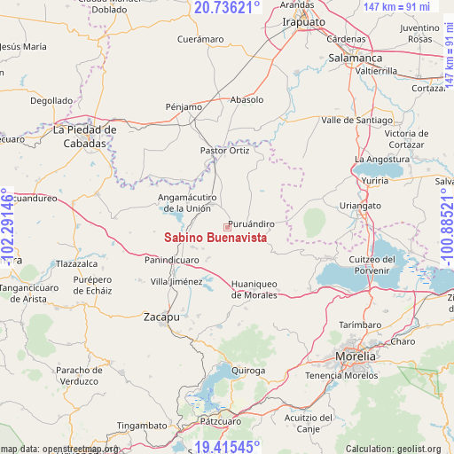
Sabino Buenavista GPS coordinates[2]
20° 4' 37.992" North, 101° 35' 17.988" West
| Map corner | latitude | longitude |
|---|---|---|
| Upper-left | 20.73621°, | -102.29146° |
| Center: | 20.07722°, | -101.58833° |
| Lower-right: | 19.41545°, | -100.88521° |
| Map W x H: | 146.9×146.9 km | = 91.3×91.3mi |
| max Lat: | 32.7° ⇑41.3% North |
| Sabino Buenavista: | 20.07722° |
| min Lat: | ⇓58.7% South 14.53588° |
| min Long | Sabino Buenavis | max Long |
| -117.105° | -101.58833° | -86.73105° |
| W 21.9%⇐ | ⇒78.1% E |
Elevation
Elevation of Sabino Buenavista is 1907 m = 6257 ft, and this is 653.3 m = 2143 ft above average elevation for this country.
| Max E: |
3497 m = 11473 ft | 31% |
| Sabino Buenavista | 1907 m 6257 ft | |
| Avg. | 1253.7 m = 4113 ft | |
Min E: |
-1 m = -3 ft | 69% |
See also: Mexico elevation on elevation.city.
Geographical zone
Sabino Buenavista is located in North Torrid zone (between Equator and Tropic of Cancer). Distance of this Northern Tropic circle is 373.5 km =232.1 mi to North.| Distance of | km | miles | from Sabino Buenavista |
|---|---|---|---|
| North Pole | 7774.7 | 4831 | to North |
| Arctic Circle | 5168.8 | 3211.7 | to North |
| Tropic Cancer | 373.5 | 232.1 | to North |
| Equator | 2232.4 | 1387.1 | to South |


Nearby cities:
15 places around Sabino Buenavista: (largest is in red/bold)
• Batuecas
12.2 km =7.6 mi,  109°
109°
• Curimeo
12.8 km =8 mi,  240°
240°
• El Maluco
11.8 km =7.3 mi,  309°
309°
• Galeana
4.9 km =3 mi,  159°
159°
• Janamuato
2.5 km =1.6 mi,  7°
7°
• La Estancia del Río
12.6 km =7.8 mi,  266°
266°
• La Excusa
12.3 km =7.6 mi,  53°
53°
• La Luz
12.8 km =8 mi,  212°
212°
• Nuevo Progreso (Casas Viejas)
7.3 km =4.5 mi, 244°
• Puruándiro
7.7 km =4.8 mi,  80°
80°
• San Lorenzo
11.5 km =7.1 mi, 211°
• San Miguel
7.2 km =4.5 mi,  234°
234°
• San Pedro (San Pedro Carano)
9.8 km =6.1 mi, 53°
• Ururuta
4.1 km =2.5 mi, 208°
• Villachuato
9.3 km =5.8 mi,  328°
328°
Sources, notices
• [Note1] Compared only with cities in Mexico existing in our database
• [Src1] Map data: © OpenStreetMap contributors (CC-BY-SA)
• [Src2] Other city data from geonames.org with taken over terms of usage.
• [Src3] Geographical zone / Annual Mean Temperature by Robert A. Rohde @ Wikipedia
