Cuautempan geodata
Cuautempan (Puebla) is a seat of a second-order administrative division; located in Mexico in America/Mexico_City (GMT-6) time zone. With population of 1,094 people, there are 7947 cities with bigger population in this country. Compared to other cities in Mexico, 55.4% of cities are located further ↓South; 66.2% of cities are located further ←West and 51.7% of cities have lower elevation than Cuautempan. Note1


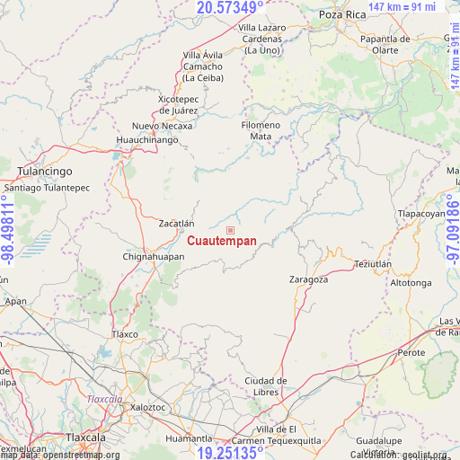
Cuautempan GPS coordinates[2]
19° 54' 49.68" North, 97° 47' 41.928" West
| Map corner | latitude | longitude |
|---|---|---|
| Upper-left | 20.57349°, | -98.49811° |
| Center: | 19.9138°, | -97.79498° |
| Lower-right: | 19.25135°, | -97.09186° |
| Map W x H: | 147×147 km | = 91.3×91.3mi |
| max Lat: | 32.7° ⇑44.6% North |
| Cuautempan: | 19.9138° |
| min Lat: | ⇓55.4% South 14.53588° |
| min Long | Cuautempan | max Long |
| -117.105° | -97.79498° | -86.73105° |
| W 66.2%⇐ | ⇒33.8% E |
Elevation
Elevation of Cuautempan is 1513 m = 4964 ft, and this is 259.3 m = 851 ft above average elevation for this country.
| Max E: |
3497 m = 11473 ft | 48.3% |
| Cuautempan | 1513 m 4964 ft | |
| Avg. | 1253.7 m = 4113 ft | |
Min E: |
-1 m = -3 ft | 51.7% |
See also: Mexico elevation on elevation.city.
Geographical zone
Cuautempan is located in North Torrid zone (between Equator and Tropic of Cancer). Distance of this Northern Tropic circle is 391.7 km =243.4 mi to North.| Distance of | km | miles | from Cuautempan |
|---|---|---|---|
| North Pole | 7792.9 | 4842.3 | to North |
| Arctic Circle | 5187 | 3223.1 | to North |
| Tropic Cancer | 391.7 | 243.4 | to North |
| Equator | 2214.2 | 1375.8 | to South |


Nearby cities:
15 places around Cuautempan: (largest is in red/bold)
• Ahuatlán
1.7 km =1.1 mi,  284°
284°
• Cerro Verde (Ejecatepeco)
1.3 km =0.8 mi,  3°
3°
• Chicometepec (San Simón)
6.4 km =4 mi,  327°
327°
• Hueytentan
4.7 km =2.9 mi,  218°
218°
• Ixtolco de Morelos
2.5 km =1.6 mi,  248°
248°
• San Antonio Taltzintán
6.6 km =4.1 mi,  94°
94°
• Tenepanigia (Santa Elena)
6.3 km =3.9 mi,  22°
22°
• Tepetzintla
7.7 km =4.8 mi,  320°
320°
• Tlamanca de Hernández
5.1 km =3.2 mi,  336°
336°
• Tlapacholoya
3.2 km =2 mi,  12°
12°
• Tonalixco
8.8 km =5.5 mi, 328°
• Totomoxtla
2.8 km =1.7 mi, 326°
• Vista Hermosa
1.3 km =0.8 mi,  107°
107°
• Xaltatempa de Lucas
6.7 km =4.2 mi,  233°
233°
• Xochitlaxco (San Baltazar)
7.8 km =4.8 mi,  293°
293°
Sources, notices
• [Note1] Compared only with cities in Mexico existing in our database
• [Src1] Map data: © OpenStreetMap contributors (CC-BY-SA)
• [Src2] Other city data from geonames.org with taken over terms of usage.
• [Src3] Geographical zone / Annual Mean Temperature by Robert A. Rohde @ Wikipedia
