Las Trancas geodata
Las Trancas (Veracruz) is a populated place; located in Mexico in America/Mexico_City (GMT-6) time zone. With population of 1,116 people, there are 7786 cities with bigger population in this country. Compared to other cities in Mexico, 53.9% of cities are located further ↑North; 76.5% of cities are located further ←West and 54.5% of cities have higher elevation than Las Trancas. Note1


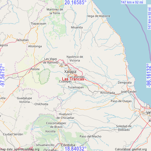
Las Trancas GPS coordinates[2]
19° 30' 15.984" North, 96° 51' 51.984" West
| Map corner | latitude | longitude |
|---|---|---|
| Upper-left | 20.16585°, | -97.56757° |
| Center: | 19.50444°, | -96.86444° |
| Lower-right: | 18.84032°, | -96.16132° |
| Map W x H: | 147.4×147.4 km | = 91.6×91.6mi |
| max Lat: | 32.7° ⇑53.9% North |
| Las Trancas: | 19.50444° |
| min Lat: | ⇓46.1% South 14.53588° |
| min Long | Las Trancas | max Long |
| -117.105° | -96.86444° | -86.73105° |
| W 76.5%⇐ | ⇒23.5% E |
Elevation
Elevation of Las Trancas is 1218 m = 3996 ft, and this is 35.7 m = 117 ft below average elevation for this country.
| Max E: |
3497 m = 11473 ft | 54.5% |
| Avg. | 1253.7 m = 4113 ft | |
| Las Trancas | 1218 m = 3996 ft | |
Min E: |
-1 m = -3 ft | 45.5% |
See also: Mexico elevation on elevation.city.
Geographical zone
Las Trancas is located in North Torrid zone (between Equator and Tropic of Cancer). Distance of this Northern Tropic circle is 437.2 km =271.7 mi to North.| Distance of | km | miles | from Las Trancas |
|---|---|---|---|
| North Pole | 7838.4 | 4870.6 | to North |
| Arctic Circle | 5232.5 | 3251.3 | to North |
| Tropic Cancer | 437.2 | 271.7 | to North |
| Equator | 2168.7 | 1347.6 | to South |


Nearby cities:
15 places around Las Trancas: (largest is in red/bold)
• Alborada
6.3 km =3.9 mi,  186°
186°
• Colonia Santa Bárbara
1.5 km =0.9 mi,  258°
258°
• Colonia la Perseverancia
1.1 km =0.7 mi,  202°
202°
• Dos Ríos
7.2 km =4.5 mi,  108°
108°
• El Castillo
4.7 km =2.9 mi,  0°
0°
• El Chico
5.2 km =3.2 mi,  145°
145°
• El Lencero
5.3 km =3.3 mi, 108°
• Estanzuela
4.9 km =3 mi,  172°
172°
• Fraccionamiento las Fuentes
2.5 km =1.6 mi,  248°
248°
• Jacarandas
1.6 km =1 mi,  128°
128°
• Lomas Verdes
2.6 km =1.6 mi,  270°
270°
• Pacho Nuevo
3.4 km =2.1 mi,  205°
205°
• Pacho Viejo
6 km =3.7 mi, 245°
• Tronconal
6.6 km =4.1 mi, 1°
• Xalapa de Enríquez
6.2 km =3.9 mi,  298°
298°
Sources, notices
• [Note1] Compared only with cities in Mexico existing in our database
• [Src1] Map data: © OpenStreetMap contributors (CC-BY-SA)
• [Src2] Other city data from geonames.org with taken over terms of usage.
• [Src3] Geographical zone / Annual Mean Temperature by Robert A. Rohde @ Wikipedia
