Jacarandas geodata
Jacarandas (Veracruz) is a populated place; located in Mexico in America/Mexico_City (GMT-6) time zone. With population of 8,351 people, there are 1140 cities with bigger population in this country. Compared to other cities in Mexico, 54.1% of cities are located further ↑North; 76.6% of cities are located further ←West and 55% of cities have higher elevation than Jacarandas. Note1


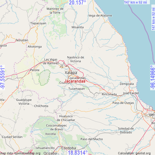
Jacarandas GPS coordinates[2]
19° 29' 44.016" North, 96° 51' 10.008" West
| Map corner | latitude | longitude |
|---|---|---|
| Upper-left | 20.157°, | -97.55591° |
| Center: | 19.49556°, | -96.85278° |
| Lower-right: | 18.8314°, | -96.14966° |
| Map W x H: | 147.4×147.4 km | = 91.6×91.6mi |
| max Lat: | 32.7° ⇑54.1% North |
| Jacarandas: | 19.49556° |
| min Lat: | ⇓45.9% South 14.53588° |
| min Long | Jacarandas | max Long |
| -117.105° | -96.85278° | -86.73105° |
| W 76.6%⇐ | ⇒23.4% E |
Elevation
Elevation of Jacarandas is 1198 m = 3930 ft, and this is 55.7 m = 183 ft below average elevation for this country.
| Max E: |
3497 m = 11473 ft | 55% |
| Avg. | 1253.7 m = 4113 ft | |
| Jacarandas | 1198 m = 3930 ft | |
Min E: |
-1 m = -3 ft | 45% |
See also: Mexico elevation on elevation.city.
Geographical zone
Jacarandas is located in North Torrid zone (between Equator and Tropic of Cancer). Distance of this Northern Tropic circle is 438.2 km =272.3 mi to North.| Distance of | km | miles | from Jacarandas |
|---|---|---|---|
| North Pole | 7839.4 | 4871.2 | to North |
| Arctic Circle | 5233.5 | 3251.9 | to North |
| Tropic Cancer | 438.2 | 272.3 | to North |
| Equator | 2167.7 | 1346.9 | to South |


Nearby cities:
15 places around Jacarandas: (largest is in red/bold)
• Alborada
5.6 km =3.5 mi,  200°
200°
• Bella Esperanza
7.1 km =4.4 mi,  191°
191°
• Colonia Santa Bárbara
2.8 km =1.7 mi,  284°
284°
• Colonia la Perseverancia
1.7 km =1.1 mi,  267°
267°
• Dos Ríos
5.7 km =3.5 mi,  102°
102°
• El Castillo
5.8 km =3.6 mi,  348°
348°
• El Chico
3.7 km =2.3 mi,  152°
152°
• El Lencero
3.9 km =2.4 mi, 100°
• El Terrero
7.3 km =4.5 mi,  50°
50°
• Estanzuela
3.9 km =2.4 mi, 188°
• Fraccionamiento las Fuentes
3.5 km =2.2 mi, 270°
• Las Trancas
1.6 km =1 mi,  308°
308°
• Lomas Verdes
3.9 km =2.4 mi, 284°
• Pacho Nuevo
3.4 km =2.1 mi,  232°
232°
• Pacho Viejo
6.8 km =4.2 mi,  257°
257°
Sources, notices
• [Note1] Compared only with cities in Mexico existing in our database
• [Src1] Map data: © OpenStreetMap contributors (CC-BY-SA)
• [Src2] Other city data from geonames.org with taken over terms of usage.
• [Src3] Geographical zone / Annual Mean Temperature by Robert A. Rohde @ Wikipedia
